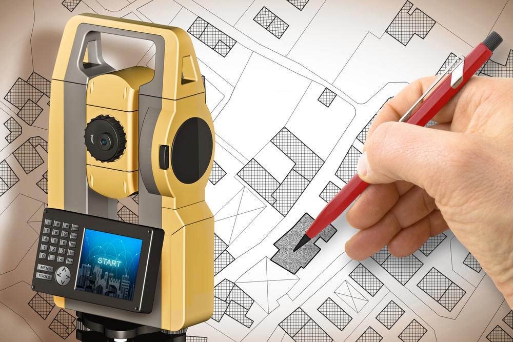
Bearing surveys are an essential component of land surveying, construction, navigation, and various engineering applications. They involve the precise measurement of angles to determine directions and locations. Within this domain, understanding the differences between circle bearing and quadrantal bearing—two common types of bearing measurement—is crucial for professionals in the field. This blog explores their unique characteristics, applications, and how they are utilized in various surveying contexts.
What Is a Bearing Survey?
A bearing survey involves measuring angles to determine the direction of a line relative to a reference direction. Bearings are expressed in degrees and used to define the orientation of lines, points, or objects. These measurements are critical in mapping, navigation, and construction to ensure accuracy and alignment.
Bearings can be classified into different types based on how the angles are measured and interpreted. The most common types include circle bearing and quadrantal bearing, each with distinct methodologies and applications.
Circle Bearing: A Comprehensive Overview
What Is Circle Bearing?
Circle bearing, also known as azimuth bearing, is a method of expressing direction by measuring the angle clockwise from a fixed reference direction, typically the north. The angle ranges from 0° to 360° and provides a complete circle of measurement.
For instance:
0° indicates north.
90° indicates east.
180° indicates south.
270° indicates west.
Key Features of Circle Bearing
Full Circle Measurement: The entire circle (360°) is divided into four quadrants, making circle bearing suitable for applications that require precise and unambiguous directions.
Clockwise Measurement: The angles are always measured in a clockwise direction from the reference north, ensuring consistency and simplicity in navigation and calculations.
Universal Applicability: Circle bearings are widely used in GPS systems, topographic surveys, and military navigation due to their global standardization and ease of integration with modern technology.
Applications of Circle Bearing
Circle bearing is extensively used in:
Navigation Systems: Modern GPS devices rely on azimuth bearings for accurate direction and position tracking.
Engineering Projects: In road construction and urban planning, circle bearings help determine alignment and orientation.
Astronomy: Telescopes often use azimuth measurements to locate celestial objects.
Quadrantal Bearing: A Closer Look
What Is Quadrantal Bearing?
Quadrantal bearing, also known as reduced bearing, is a system of measuring angles relative to the nearest north-south axis. The angles are expressed in terms of quadrants (NE, SE, SW, NW) and range between 0° to 90° in each quadrant.
For instance:
N30°E indicates a line oriented 30° east of the north axis.
S45°W indicates a line oriented 45° west of the south axis.
Key Features of Quadrantal Bearing
Four Quadrants: The system divides the compass into four quadrants, each representing a 90° section, simplifying angular measurements.
Relative Direction: Bearings are referenced from the nearest north-south line rather than from a single fixed direction like circle bearing.
Ease of Understanding: Quadrantal bearings are intuitive for fieldwork and small-scale applications, as they clearly define both direction and angle.
Applications of Quadrantal Bearing
Quadrantal bearings are commonly used in:
Land Surveys: Ideal for localized land measurements where simplicity and clarity are paramount.
Architecture: Often applied to small-scale construction projects for layout and orientation.
Maritime Navigation: Quadrantal bearings are historically significant in marine navigation for defining ship courses.
Differences Between Circle Bearing and Quadrantal Bearing
To better understand these two types of bearing measurement, let’s explore their differences across key parameters:
1. Range of Angles
Circle bearing: Ranges from 0° to 360°, covering the entire circle.
Quadrantal bearing: Ranges from 0° to 90° within each quadrant.
2. Reference Direction
Circle bearing: Uses the north direction as a fixed reference, with angles measured clockwise.
Quadrantal bearing: Uses the nearest north-south line as a reference, with angles measured toward the east or west.
3. Notation
Circle bearing: Expressed as a single angle, e.g., 135°.
Quadrantal bearing: Includes directional notation, e.g., N45°E or S60°W.
4. Application Context
Circle bearing: Suitable for large-scale and high-precision projects like road alignments and GPS mapping.
Quadrantal bearing: Ideal for localized surveys and projects where simplicity is a priority.
5. Ease of Use
Circle bearing: May require more training to interpret, especially for non-experts.
Quadrantal bearing: More intuitive and user-friendly for those with minimal technical expertise.
Choosing Between Circle Bearing and Quadrantal Bearing
When selecting a bearing system, the choice depends on the specific requirements of the project or application. Here are some factors to consider:
Scale of the Project
Large-Scale Projects: For projects like highway design, pipeline alignment, and regional surveys, circle bearing is preferred due to its precision and integration with advanced tools.
Small-Scale Projects: Quadrantal bearing is more practical for localized tasks such as boundary marking or small construction layouts.
Accuracy Requirements
High Accuracy: Circle bearing is the go-to option when precise angular measurements are critical.
Moderate Accuracy: Quadrantal bearing suffices for projects where moderate precision is acceptable.
User Proficiency
Trained Professionals: Circle bearing is often used by experienced surveyors and engineers.
General Use: Quadrantal bearing is suitable for less complex applications and users with limited technical knowledge.
Practical Examples of Circle and Quadrantal Bearings in Action
Circle Bearing Example:
A surveyor determines the bearing of a line running from a starting point to a destination point. Using circle bearing, the angle is measured as 215°, indicating the line runs in a southwesterly direction.
Quadrantal Bearing Example:
The same line measured with quadrantal bearing might be expressed as S35°W, clearly indicating its direction relative to the south and west.
Benefits of Understanding Both Systems
Familiarity with both circle and quadrantal bearings offers several advantages:
Versatility: Enables professionals to adapt to different projects and tools.
Error Reduction: Minimizes mistakes caused by misinterpreting directional data.
Enhanced Communication: Facilitates clear and consistent information exchange among teams.
Conclusion
The differences between circle bearing and quadrantal bearing lie in their range, reference direction, notation, and applications. While circle bearing provides a full-circle measurement for large-scale and precision-demanding tasks, quadrantal bearing offers simplicity and clarity for smaller projects.
Understanding these distinctions allows professionals to choose the right system for their needs, ensuring accuracy and efficiency in surveying and navigation. Whether you’re charting a course across the seas or marking boundaries for a construction site, the right bearing system can make all the difference.
Need Land Surveyors in Texas?
At Smyth Surveyors, Inc., we offer professional, official, and dependable land surveying in Texas. Our staff are all trained and licensed with our owner holding an L.S.L.S license. We can offer surveying for gas and oil well locations, pipeline right-of-way acquisition and construction alignment, determination of original survey boundaries, title boundary surveys, topographic surveys, and construction staking. If you are looking for a surveying company that has a prestigious record and an impeccable reputation look no further than Smyth Surveyors, Inc. Contact us today to speak with one of our friendly project managers and set up some time with us!
Understanding property boundaries is essential for homeowners, real estate developers, and potential buyers. A boundary survey is a critical tool used to determine the precise legal boundaries and corners of a property. Whether you’re looking to build a fence, sell land, or settle a property dispute, knowing your property’s boundary lines ensures clarity and prevents legal conflicts. This blog will explore the various applications of a boundary survey and its importance in property management.
What Is a Boundary Survey?
A boundary survey is a process conducted by a licensed surveyor to determine the exact property lines and corners of a parcel of land. This survey identifies the precise legal boundaries as outlined in a deed or plat map. It involves examining historical records, conducting on-site measurements, and using advanced technology like GPS to ensure accuracy.
Boundary surveys are used in multiple scenarios, from defining property’s boundary lines for construction to resolving disputes between neighbors. They provide a documented foundation for understanding property dimensions and ownership rights.
Applications of a Boundary Survey
Confirming Legal Boundaries and Corners
One of the most fundamental uses of a boundary survey is to confirm the legal boundaries and corners of a property. This is crucial in situations where property owners are uncertain about the exact extent of their land. A survey ensures that all structures, fences, and improvements remain within the correct property lines. Without a boundary survey, property owners may unintentionally encroach on neighboring lands, leading to potential legal disputes.
Benefits:
Avoid encroachments by staying within your legal property lines.
Protect against disputes with neighbors.
Accurately document the dimensions of your property for future reference.
Facilitating Property Sales or Purchases
When buying or selling property, clarity regarding boundary lines is essential. A boundary survey provides potential buyers with confidence that the property aligns with its description in legal documents. It also helps sellers avoid disputes or delays during the transaction process.
Key Insights:
Buyers gain assurance that they are purchasing the correct parcel of land.
Sellers can establish trust by providing verified boundary documentation.
Lending institutions often require a boundary survey before approving loans.
Construction and Landscaping Projects
Before beginning any construction or landscaping project, such as building a home, installing a fence, or creating a garden, knowing your property’s boundary lines is essential. A boundary survey prevents costly mistakes caused by building on land that isn’t yours.
Why It Matters:
Prevents legal and financial complications due to encroachments.
Ensures that new structures comply with zoning regulations and setback requirements.
Guides architects and contractors in designing projects that fit within the property’s boundaries.
Resolving Boundary Disputes
Boundary disputes between neighbors can arise for various reasons, such as overlapping fences, unclear property descriptions, or differing interpretations of deeds. A boundary survey serves as an impartial tool to resolve these disputes by defining the exact limits of each property.
How a Survey Helps:
Establishes clear boundaries backed by legal documentation.
Provides evidence in court if disputes escalate to litigation.
Facilitates amicable resolution between parties.
Subdividing Land
If you plan to subdivide your property into smaller lots for sale or development, a boundary survey is indispensable. The survey ensures that the new parcels are accurately measured and legally compliant with local zoning laws.
Benefits of Subdivision Surveys:
Creates legally recognized parcels with precise measurements.
Prevents overlapping or misaligned property lines.
Helps developers maximize the use of available land.
Meeting Local and State Regulations
Boundary surveys often serve as a requirement for compliance with local and state regulations. For instance, zoning laws may mandate a boundary survey before issuing permits for construction or land development.
Examples:
Compliance with setback requirements for new buildings.
Ensuring adherence to municipal planning guidelines.
Avoiding fines or delays caused by regulatory non-compliance.
Establishing Easements
An easement grants someone the right to use a portion of your property for a specific purpose, such as utility lines or shared driveways. A boundary survey clarifies the location and dimensions of easements, ensuring that all parties understand their rights and obligations.
Key Benefits:
Prevents misuse or overextension of easement rights.
Protects property owners by documenting legal agreements.
Helps resolve conflicts related to easement usage.
How Is a Boundary Survey Conducted?
The process of a boundary survey involves several key steps to ensure accuracy and compliance with legal standards:
Research and Preparation
Surveyors begin by researching historical records, including deeds, plats, and previous surveys. This helps them understand the legal descriptions and any potential discrepancies.
Fieldwork
Using specialized tools like GPS and total stations, surveyors measure the property on-site. They locate existing markers, such as stakes or monuments, and set new ones if necessary.
Data Analysis
Surveyors analyze the field data to confirm that the property’s boundary lines align with the legal descriptions in the deed. Any discrepancies are addressed during this phase.
Documentation
The final step is creating a detailed survey map, which includes:
Exact property lines and dimensions.
Locations of legal boundaries and corners.
Notes on easements, encroachments, or discrepancies.
The Importance of Hiring a Licensed Surveyor
A boundary survey must be conducted by a licensed professional to ensure its legal validity. Licensed surveyors have the expertise, training, and equipment needed to deliver accurate results. Additionally, their findings are recognized by courts and government agencies, making their surveys essential for legal and regulatory purposes.
Common Mistakes to Avoid with Boundary Surveys
Assuming Boundary Markers Are Accurate
Old boundary markers may have shifted over time, leading to inaccuracies. Always verify boundaries through a professional survey.
Skipping a Survey for Small Projects
Even small projects, such as planting a hedge or building a shed, can lead to disputes if property lines are unclear. Investing in a survey prevents potential headaches.
Ignoring Easements or Rights of Way
Failing to consider easements can result in legal complications. A boundary survey highlights these areas, ensuring compliance with agreements.
Costs of a Boundary Survey
The cost of a boundary survey varies depending on factors such as property size, terrain, and complexity. While it may seem like an additional expense, the long-term benefits far outweigh the costs. Accurate boundary documentation can save thousands of dollars in potential disputes, legal fees, or construction adjustments.
Conclusion
A boundary survey is an invaluable tool for anyone involved in property ownership, development, or management. By defining legal boundaries and corners, it ensures that property owners fully understand their property’s boundary lines, reducing the risk of disputes and legal complications. Whether you’re planning construction, buying a new home, or addressing a boundary conflict, a boundary survey provides the clarity and peace of mind needed to move forward confidently.
Investing in a professional boundary survey is not just a financial decision—it’s a step toward protecting your property rights and ensuring the accurate representation of your land.
Need Land Surveyors in Texas?
At Smyth Surveyors, Inc., we offer professional, official, and dependable land surveying in Texas. Our staff are all trained and licensed with our owner holding an L.S.L.S license. We can offer surveying for gas and oil well locations, pipeline right-of-way acquisition and construction alignment, determination of original survey boundaries, title boundary surveys, topographic surveys, and construction staking. If you are looking for a surveying company that has a prestigious record and an impeccable reputation look no further than Smyth Surveyors, Inc. Contact us today to speak with one of our friendly project managers and set up some time with us!
A career in land surveying offers a unique blend of technology, engineering, and the outdoors, making it a highly rewarding profession for those with a passion for both precision and exploration. But where does one start if they aspire to become a professional land surveyor? This blog will guide you through the educational and training pathways needed to start a successful career in land surveying.
The Role of a Land Surveyor
Land surveyors play a critical role in the planning, design, and development of land for construction, mapping, and resource management. They use specialized equipment and techniques to measure and map the Earth’s surface, establishing land boundaries, and assisting in the legal descriptions used in real estate transactions.
Surveying isn’t just about maps and measurements; it’s about interpreting data to ensure properties are accurately delineated, which has substantial implications in real estate, construction, and government planning. For those who enjoy mathematics, engineering principles, and using cutting-edge technology like GPS and drones, a career in land surveying offers diverse and engaging opportunities.
The Pathway to Becoming a Land Surveyor
Step 1: Education Requirements
One of the first steps to launching a career in land surveying is acquiring the necessary education. Most surveyors start with a degree in land surveying or a closely related field. Here’s a breakdown of the educational paths available:
Option 1: Bachelor’s Degree in Land Surveying or Geomatics
A bachelor’s degree in land surveying or geomatics provides students with the technical foundation and practical skills required for the profession. Coursework typically covers topics such as:
Geodesy (the science of measuring the Earth)
Cartography (mapmaking)
GPS and GIS technologies
Photogrammetry
Environmental law and ethics
This four-year degree is the most direct route to qualifying for a surveying license in many countries. Many universities offer specialized programs in surveying and geomatics, combining classroom learning with fieldwork, which is essential for building practical experience.
Option 2: Associate Degree in Land Surveying
For those looking for a quicker entry point into the field, an associate degree in land surveying is an alternative. This two-year program introduces students to the basics of surveying, including fundamental mathematics, GPS applications, and equipment operation. While a bachelor’s degree is often preferred, an associate degree can provide a solid start, especially when paired with on-the-job training.
Option 3: Degree in a Related Field
Some surveyors begin with a degree in related fields like civil engineering, geography, or environmental science. With additional coursework in surveying principles and certification, professionals with these degrees can transition into a surveying career. However, it’s essential to ensure that the program includes coursework required for licensing.
Step 2: Licensure and Certification
Licensure requirements for land surveyors vary depending on the region or country, but most areas mandate that surveyors hold a license to practice independently. Here’s an outline of what you’ll need:
Fundamental of Surveying (FS) Exam
In the United States, for example, aspiring surveyors typically begin by passing the Fundamental of Surveying (FS) exam, which covers the essential principles of surveying. This exam is generally taken after completing the required educational program and is the first step toward obtaining a Professional Surveyor (PS) license.
Professional Surveyor (PS) Exam
Once you have completed the FS exam, the next step is gaining experience in the field. Typically, you’ll need around four years of work experience under the supervision of a licensed surveyor. After completing this on-the-job training, you can then sit for the Professional Surveyor (PS) exam, which is required for full licensure.
Certification for Specializations
Some surveyors choose to obtain additional certifications in areas such as GIS (Geographic Information Systems), photogrammetry, or hydrographic surveying. These certifications can be valuable for those looking to specialize in niche areas within surveying.
Finding the Right School for Your Surveying Degree
With education being the first step to entering the surveying profession, selecting the right program is crucial. Many universities and community colleges offer degrees in land surveying, geomatics, and related fields. Here are some factors to consider when choosing a program:
Accreditation
It’s essential to ensure that the program is accredited by a relevant body, such as ABET (Accreditation Board for Engineering and Technology) in the United States. Accreditation ensures that the curriculum meets industry standards, which is critical for licensure and employment.
Location
Since surveying is a field-based profession, consider programs that offer fieldwork opportunities or partnerships with local surveying firms. Some programs have close ties to industry professionals, which can help students gain practical experience and build networks.
Technology and Equipment
Surveying relies on technology, from drones and GPS equipment to specialized software for mapping and data analysis. Choose a program that provides access to up-to-date technology and offers hands-on training.
Online vs. In-Person Programs
With advancements in online education, some universities offer online courses or hybrid programs in surveying. These can be convenient for those needing flexibility, but be sure that the program includes opportunities for field training, as practical experience is essential in this profession.
Building a Strong Skill Set for Surveying
While formal education and licensure are critical, there are additional skills that can set you apart in a career in land surveying:
Technical Skills
Modern surveyors use advanced technology, including GPS, GIS, and laser scanners. Familiarity with these tools and the ability to interpret digital data is essential. Many degree programs will offer training in these areas, but consider additional workshops or online courses to enhance your proficiency.
Analytical Skills
Surveying requires precise measurement and data analysis. Strong mathematical skills, particularly in geometry, algebra, and trigonometry, are necessary for calculating distances, angles, and elevations. Analytic skills also help surveyors interpret legal documents and work effectively with other professionals.
Communication and Collaboration
Surveyors frequently work with engineers, architects, urban planners, and government officials. Being able to communicate clearly and work well with a team is vital to the profession, especially when conveying complex information to clients or stakeholders.
Attention to Detail
The smallest measurement error can have significant consequences in surveying. An eye for detail and a commitment to accuracy are essential for surveyors, particularly in tasks involving property boundaries and construction layout.
Gaining Field Experience and Networking
Education is a great start, but real-world experience is invaluable in building a successful surveying career. Here’s how to gain hands-on experience:
Internships and Apprenticeships
Many surveying programs require or encourage internships, providing students with supervised experience in the field. Apprenticeships are also an option, allowing trainees to work directly with experienced surveyors to gain practical knowledge.
Networking and Professional Organizations
Joining professional organizations, such as the National Society of Professional Surveyors (NSPS) in the United States or the Royal Institution of Chartered Surveyors (RICS) in the UK, can open up networking opportunities and keep you updated on industry developments. These organizations often offer student memberships, mentoring programs, and job boards.
Continued Learning and Professional Development
The surveying profession continually evolves, particularly with technological advancements like drones and 3D mapping. To stay competitive and informed, participate in continued learning opportunities offered by professional organizations, attend industry conferences, and stay updated on emerging trends.
Career Paths in Land Surveying
Once you have a degree in land surveying and the required licensure, several career paths and specializations are available. Here are some common options:
Boundary Surveyor
Boundary surveyors focus on determining property lines and resolving legal boundary disputes. This is a foundational area of surveying with direct applications in real estate, construction, and municipal planning.
Hydrographic Surveyor
Hydrographic surveyors map underwater areas, including the sea floor, rivers, and lakes, and are essential in marine navigation and offshore construction. This role often requires specialized equipment and additional certifications.
Geodetic Surveyor
Geodetic surveyors measure large areas of the Earth’s surface using satellite and aerial technology. They work on a regional or national scale and contribute to large mapping projects.
Forensic Surveyor
Forensic surveyors work in legal settings, providing evidence in boundary disputes or accident reconstructions. They may be called upon to testify in court regarding their findings.
The Rewarding Career of a Land Surveyor
A career in land surveying offers diverse opportunities and the chance to make a meaningful impact on society. Surveyors contribute to the integrity of property ownership, play a role in the infrastructure of cities, and provide essential services to construction and environmental projects. Starting with a degree in land surveying and gaining licensure sets the foundation, while field experience and networking build the pathway to a successful career in this dynamic field.
Whether you choose to specialize in boundary surveying, GIS mapping, or marine surveying, a career in land surveying offers a balanced blend of technology, hands-on work, and problem-solving, making it a fulfilling choice for those drawn to technical expertise and outdoor work.
Need Land Surveyors in Texas?
At Smyth Surveyors, Inc., we offer professional, official, and dependable land surveying in Texas. Our staff are all trained and licensed with our owner holding an L.S.L.S license. We can offer surveying for gas and oil well locations, pipeline right-of-way acquisition and construction alignment, determination of original survey boundaries, title boundary surveys, topographic surveys, and construction staking. If you are looking for a surveying company that has a prestigious record and an impeccable reputation look no further than Smyth Surveyors, Inc. Contact us today to speak with one of our friendly project managers and set up some time with us!
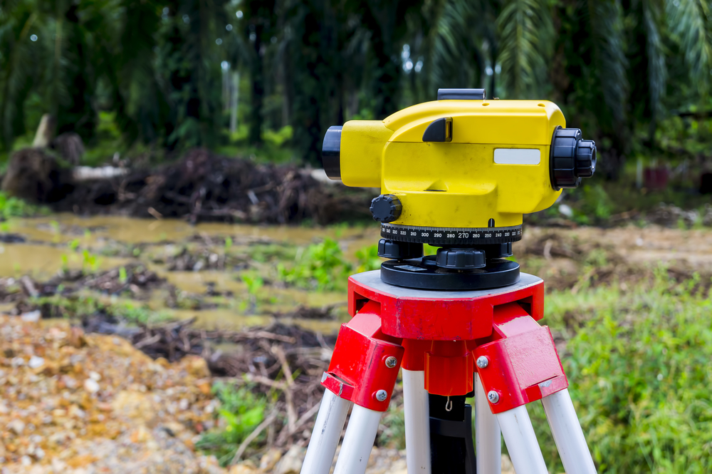
Auto level surveying is a fundamental process in construction, engineering, and land surveying that ensures accurate level measurements over various terrains. Auto level devices, which streamline the process, have become invaluable in these industries due to their efficiency, reliability, and precision. This article explores how auto level surveying is conducted and the many advantages of using auto level devices in modern surveying practices.
What Is Auto Level Surveying?
Auto level surveying, also known as leveling or differential leveling, is a method used to determine the height or elevation difference between two or more points. The primary goal is to achieve accurate, level surfaces, which is critical in construction projects and land assessments. By employing auto level devices, surveyors and engineers can measure and record these height differences more accurately and with greater consistency.
Auto level surveying requires a few essential tools, including an auto level (a telescopic leveling instrument), a tripod, and a leveling rod or staff. These devices help surveyors measure and record the differences in height over long distances without moving the equipment frequently. The result is a reliable, efficient method of ensuring that surfaces are level, an essential requirement in numerous industries.
Understanding Auto Level Devices
Auto level devices are specialized instruments that simplify and improve the surveying process. They come equipped with an internal compensator, a mechanism that automatically adjusts the line of sight, ensuring that the measurement remains level even on uneven ground. This adjustment prevents errors that would occur if the device were tilted slightly, making it easier for surveyors to achieve consistent accuracy in their readings.
Key Features of Auto Level Devices
Auto level devices boast several features that make them indispensable in modern surveying:
Automatic Compensator: The internal compensator mechanism keeps the line of sight perfectly level, which is essential in reducing errors.
Telescope and Optical Lens: The telescope enables surveyors to view distant points clearly, while high-quality lenses ensure clarity and precision.
Sturdy Build: These devices are typically built to withstand rugged conditions, allowing for accurate surveying even in challenging environments.
Calibration Adjustments: Auto levels can be calibrated easily, ensuring consistent accuracy over extended use.
Simple Setup: Designed for efficiency, auto level devices are quick to set up, allowing surveyors to begin measurements without delay.
By combining these features, auto level devices make surveying faster, more reliable, and accessible to a wide range of users, from novices to experienced professionals.
How Is Auto Level Surveying Conducted?
Conducting an auto level survey involves several key steps that ensure accurate measurements across the surveyed area. These steps are straightforward, yet following them precisely is essential to obtaining reliable data.
Step 1: Setting Up the Tripod
The first step is to set up the tripod, ensuring that it is stable on the ground. The tripod is typically positioned over a known reference point or benchmark, which serves as the initial height measurement for the survey. Surveyors adjust the legs of the tripod to ensure it is level, as this will support the accuracy of the subsequent measurements.
Step 2: Mounting and Leveling the Auto Level Device
Once the tripod is in place, the auto level device is mounted on top of it. Surveyors adjust the device’s leveling screws, and the internal compensator ensures the line of sight remains level. This feature eliminates the need for manual leveling, reducing the likelihood of error and making the setup process quicker and more efficient.
Step 3: Taking Measurements
With the auto level device in place, the surveyor can now focus on measuring the height differences between various points. A leveling rod or staff is placed at each point to be measured, and the surveyor looks through the telescope to read the measurements on the rod. By comparing the measurements at different points, surveyors can calculate the elevation differences across the terrain.
Step 4: Recording and Calculating Data
After taking the measurements, the surveyor records the data, which is then used to calculate the height differences. This data can be analyzed to determine slopes, elevations, and contours, which are essential for planning construction projects or mapping land features. With auto level surveying, these calculations are highly accurate, providing a reliable basis for further planning.
Applications of Auto Level Surveying
Auto level surveying is used in a wide range of applications, from construction to environmental management. The versatility and accuracy of auto level devices make them a preferred choice in several industries.
Construction Industry
In the construction industry, auto level surveying is essential for creating level foundations, setting elevations for floors, and ensuring structural components are aligned accurately. This accuracy prevents future structural issues, ensuring the stability and longevity of buildings, roads, and other infrastructure.
Civil Engineering Projects
Civil engineers use auto level devices to plan and execute projects that require precise level measurements. Auto level surveying plays a vital role in constructing bridges, tunnels, dams, and roadways, where accurate elevations are crucial for safety and functionality.
Land Surveying and Mapping
Land surveyors rely on auto level surveying to map out land boundaries, contours, and elevations. This information is invaluable for creating topographic maps, managing land resources, and preparing land for agricultural or residential use.
Environmental and Geological Studies
Auto level surveying is also employed in environmental and geological studies, where understanding elevation changes can help monitor soil erosion, river paths, and forest growth. Accurate leveling aids researchers in studying terrain changes over time, which is critical in understanding ecological trends and mitigating environmental risks.
The Advantages of Using Auto Level Surveying
Auto level surveying offers numerous benefits over traditional leveling methods, enhancing accuracy, efficiency, and reliability in various surveying tasks. Here are some of the top advantages of using auto level devices:
High Precision and Accuracy
Auto level devices are renowned for their accuracy, as they eliminate errors caused by manual adjustments. The automatic compensator keeps the line of sight level, ensuring precise readings even on uneven surfaces. This high degree of accuracy is crucial for construction projects, where even minor errors can have significant consequences.
Increased Efficiency
Compared to manual leveling methods, auto level surveying is faster and more efficient. Auto level devices are designed for quick setup, and the automatic leveling feature minimizes the need for constant adjustments. This efficiency enables surveyors to cover larger areas in less time, which is particularly beneficial on large construction sites or extensive land surveys.
Reduced Human Error
Auto level devices are built to reduce human error by automatically adjusting to ensure level measurements. This feature means that less experienced surveyors can still achieve accurate results, making the devices accessible to a broader range of users. By eliminating the risk of minor alignment mistakes, auto level devices produce more consistent and reliable data.
Durable and Suitable for Various Environments
Many auto level devices are designed to withstand challenging environments, including rough terrains and adverse weather conditions. This durability makes them ideal for outdoor use, allowing surveyors to conduct accurate surveys regardless of environmental factors. The resilience of auto level devices ensures that they remain a reliable tool over extended periods and in demanding conditions.
Cost-Effective and Long-Lasting
Investing in an auto level device can lead to significant cost savings in the long run. Their durability and minimal maintenance requirements make them a cost-effective choice for companies that conduct frequent surveys. Additionally, their accuracy reduces the likelihood of costly errors in construction and engineering projects, further enhancing their value.
Versatile Across Multiple Applications
Auto level surveying is highly versatile, as it can be used in various applications, from construction and engineering to environmental studies and land mapping. This adaptability makes auto level devices a valuable tool for professionals across multiple industries, as they can be used in a wide array of projects and settings.
Choosing the Right Auto Level Device
Selecting an auto level device that suits the needs of a specific project or industry is essential to fully leveraging the benefits of auto level surveying. Factors to consider include the device’s magnification, durability, ease of calibration, and compatibility with other surveying tools. Consulting with experienced professionals or seeking product reviews can help surveyors find a device that meets their requirements and fits within their budget.
Why Auto Level Surveying is Essential
Auto level surveying has become an indispensable part of modern surveying and construction practices. By using auto level devices, surveyors and engineers gain access to high-precision, efficient, and reliable measurement tools, enhancing the accuracy of their work and supporting a wide range of applications. From leveling building foundations to mapping expansive terrains, auto level surveying provides a foundation of accuracy and reliability that underpins successful project outcomes. The advantages of using auto level devices—such as reduced human error, increased efficiency, and enhanced precision—make them a top choice for professionals across diverse fields.
Auto level surveying continues to evolve with advancements in technology, ensuring that it remains a crucial method for achieving level measurements that meet the exacting standards of today’s projects. As industries increasingly rely on data-driven precision, auto level devices play a vital role in delivering the reliable information needed to build, map, and manage the world around us.
Need Land Surveyors in Texas?
At Smyth Surveyors, Inc., we offer professional, official, and dependable land surveying in Texas. Our staff are all trained and licensed with our owner holding an L.S.L.S license. We can offer surveying for gas and oil well locations, pipeline right-of-way acquisition and construction alignment, determination of original survey boundaries, title boundary surveys, topographic surveys, and construction staking. If you are looking for a surveying company that has a prestigious record and an impeccable reputation look no further than Smyth Surveyors, Inc. Contact us today to speak with one of our friendly project managers and set up some time with us!
Purchasing a residential home in Uvalde County is an exciting milestone, especially for a first-time property owner. But along with this excitement comes the responsibility of ensuring that you have a full understanding of the property and its boundaries. One crucial step that should not be overlooked is obtaining a property survey before finalizing your purchase. This guide will break down what a property survey is, why it’s important, and whether you need one for your home purchase in Uvalde County.
What is a Property Survey?
A property survey is a detailed map of the property you are purchasing, showing its boundaries, structures, and any encroachments or easements that might affect the land. It also includes the property’s legal description, which is essential for any official records or documentation.
The property survey is conducted by a licensed surveyor who physically inspects the property, measures its boundaries, and notes any features like fences, driveways, or buildings that may not be accurately represented on previous maps or title documents.
Types of Property Surveys
Several types of surveys can be done depending on the purpose and specific details needed:
Boundary Survey: This type of survey determines the exact property lines and helps to identify any discrepancies in the boundaries. It’s crucial for settling disputes with neighbors or confirming the legal property limits.
Location Survey: This is similar to a boundary survey but includes information about the location of structures on the property. It is often used for residential purchases.
Topographic Survey: This survey focuses on the natural and man-made features of the land, such as elevations, trees, and drainage systems. While not always necessary for home purchases, it can be useful if you plan to make significant changes to the property.
ALTA/NSPS Survey: This is the most comprehensive survey, often required for commercial properties. It provides extensive detail and is used for title insurance purposes. While it may not be necessary for a typical residential home purchase, it can be requested if you’re looking for a higher level of detail.
Why You Should Consider a Property Survey in Uvalde County
If you’re buying a home in Uvalde County, understanding the property boundaries and features is critical. Here’s why a survey is essential, especially for a first-time property owner:
1. Confirm the Property’s Legal Description
One of the primary reasons to have a property survey conducted is to confirm the property’s legal description. This description is a detailed and precise account of the boundaries and size of your property, which is necessary for legal documentation, such as the deed and mortgage paperwork. Without an accurate legal description, you could face challenges when trying to resell the home, build an addition, or settle boundary disputes with neighbors.
2. Avoid Boundary Disputes
Boundary disputes can become costly and stressful if not addressed early. A property survey will clearly define the exact property lines, ensuring that you don’t inadvertently encroach on a neighbor’s land or vice versa. In rural areas like Uvalde County, where property boundaries may not always be marked or fenced, a survey can prevent misunderstandings that might arise after your purchase.
3. Identify Easements or Encroachments
A survey can reveal any easements or encroachments that may affect the property. An easement is a legal right for someone else to use part of your property for a specific purpose, such as utility access or a shared driveway. Encroachments occur when part of a structure, like a fence or shed, crosses over the boundary line into a neighbor’s property or vice versa. Knowing about these issues beforehand allows you to address them before completing the purchase.
4. Protect Your Investment
For any first-time property owner, protecting your investment is paramount. Purchasing a home is one of the largest financial commitments you’ll make, so it’s essential to know exactly what you’re buying. A property survey ensures there are no surprises, such as encroachments, incorrect property boundaries, or legal issues related to easements. By having this information upfront, you can avoid future legal battles or costly repairs.
When Is a Property Survey Required?
Although a property survey isn’t always legally required for a residential home purchase in Uvalde County, there are several situations where it may be mandatory or highly recommended:
1. Title Insurance Requirements
Some title insurance companies require a property survey as part of their policy to ensure there are no disputes or issues with the property’s boundaries or legal description. This can protect both you and the lender from potential future claims against the property. Even if your title insurance provider doesn’t require a survey, it may still be worth considering for peace of mind.
2. Mortgage Lender Requirements
Certain mortgage lenders may require a survey before approving a loan. This ensures that the lender knows the exact boundaries of the property they are financing. While not all lenders in Uvalde County will require a survey, it’s best to check with your specific lender early in the process.
3. Substantial Changes to the Property
If you plan to make any substantial changes to the property, such as building a fence, garage, or addition, a property survey is essential. It will ensure that any new structures are built within the legal property boundaries and prevent future disputes with neighbors or potential issues when reselling the home.
Do I Need a Survey as a First-Time Property Owner?
For a first-time property owner in Uvalde County, getting a property survey is strongly recommended, even if it’s not required by your lender or title insurance company. Here are a few reasons why:
Peace of Mind
Purchasing your first home is a significant emotional and financial investment. A property survey provides peace of mind by ensuring there are no boundary issues, encroachments, or other legal concerns that could create headaches down the road. It’s an extra layer of protection for your investment.
Prevent Future Legal Issues
A property survey helps to prevent future legal issues by clearly outlining the property’s legal description and boundaries. Without a survey, you may encounter boundary disputes or legal challenges that could have been avoided. For a first-time property owner, navigating these issues without prior experience can be particularly stressful.
Negotiation Leverage
If the survey reveals any problems with the property’s boundaries, easements, or encroachments, you may have leverage in negotiations with the seller. For example, if a neighbor’s fence encroaches on your potential property, you could ask the seller to address the issue before closing the deal. This can save you from future legal battles and costly repairs.
How to Get a Property Survey in Uvalde County
If you decide to get a property survey done, the next step is to hire a licensed surveyor in Uvalde County. Your real estate agent or attorney may be able to recommend a reputable local surveyor, or you can research surveyors online. Once hired, the surveyor will visit the property, take measurements, and create a detailed report that includes the property’s legal description, boundary lines, and any other relevant information.
Costs of a Property Survey
The cost of a property survey in Uvalde County can vary based on factors like the size of the property, the type of survey you need, and the specific surveyor you hire. On average, a basic boundary survey for a residential property can range from $400 to $700. More detailed surveys, such as topographic or ALTA/NSPS surveys, can cost more.
Conclusion
While a property survey might not always be legally required for a residential home purchase in Uvalde County, it is a critical step in protecting your investment, especially for a first-time property owner. A survey provides an accurate property’s legal description, identifies any potential boundary or legal issues, and gives you peace of mind before finalizing your purchase. Consider the long-term benefits and potential savings when deciding whether to include a survey as part of your home-buying process.
Need Land Surveyors in Texas?
At Smyth Surveyors, Inc., we offer professional, official, and dependable land surveying in Texas. Our staff are all trained and licensed with our owner holding an L.S.L.S license. We can offer surveying for gas and oil well locations, pipeline right-of-way acquisition and construction alignment, determination of original survey boundaries, title boundary surveys, topographic surveys, and construction staking. If you are looking for a surveying company that has a prestigious record and an impeccable reputation look no further than Smyth Surveyors, Inc. Contact us today to speak with one of our friendly project managers and set up some time with us!