When Would You Use Theodolite Surveying?
Theodolite surveying is a precise and reliable method used in various surveying applications. This traditional surveying technique finds its application in multiple situations where accurate measurements and angles are necessary. Let’s explore some scenarios where theodolite surveying is commonly utilized.
Construction Projects
One of the primary applications of theodolite surveying is in construction projects. Whether it’s for a new building, road, or infrastructure development, theodolites are used to determine precise angles, elevations, and positions. Construction sites require accurate measurements to ensure structures are aligned correctly and land grading is conducted accurately. Theodolites are especially useful for setting out building corners, determining foundation elevations, and measuring slopes.
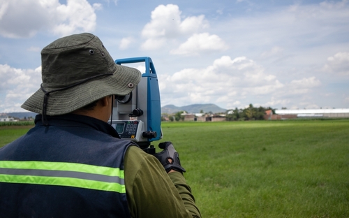
Land Surveying
Land surveying is another field where theodolites are heavily used. When determining property boundaries or conducting topographic surveys, theodolites are crucial in collecting accurate angular and directional measurements. By precisely measuring the horizontal and vertical angles from a fixed point, surveyors can create detailed maps and plans of the land. Theodolite surveying allows for precise determination of distances, elevations, and contours, aiding in creating accurate cadastral records and legal documentation.
Geodetic Surveys
Geodetic surveys involve large-scale measurements over extended areas, such as entire states or countries. Theodolites play a vital role in this type of surveying by measuring angles and distances between control points. By incorporating theodolite observations with satellite positioning systems (GPS), geodetic surveyors can determine the precise coordinates and elevations of control points in a geodetic network. This data is crucial in accurately defining boundaries, determining land heights, and monitoring tectonic plate movements.
Engineering Surveys
Theodolite surveying is extensively used in engineering surveys to ensure the proper construction and alignment of infrastructure projects such as bridges, tunnels, and pipelines. Engineers rely on theodolite measurements to assess the alignment and gradient of these structures. By measuring vertical and horizontal angles, engineers can ensure that the structures are built within the required tolerances and guidelines. Theodolite surveying provides critical information for planning, design, and construction phases of engineering projects.
Mining and Quarrying Operations
In mining and quarrying operations, theodolite surveying is employed to create precise topographic maps, measure stockpile volumes, and calculate pit depths. Using theodolites, surveyors can establish control points and accurately measure horizontal and vertical angles to determine the shape and boundaries of mining areas. These measurements help in determining the exact quantities of materials extracted and assessing the overall volume and configuration of the mining operation.
Environmental Studies
Theodolite surveying is often used in environmental studies, specifically for monitoring and studying landforms, slopes, and natural features. By using theodolites, surveyors can collect data regarding horizontal and vertical angles, allowing for the accurate measurement of steepness, aspect, and slope stability. This information is crucial in identifying potential hazards and assessing the impact of natural events, like landslides or erosion, on the environment.
Summary
Theodolite surveying is a versatile and valuable technique utilized in a range of applications. From construction projects to land surveys, geodetic surveys to engineering surveys, mining operations to environmental studies, theodolite surveying provides accurate measurements, angles, and positions essential in determining boundaries, planning projects, and monitoring environmental changes. With its precision and reliability, theodolite surveying continues to play a vital role in various industries where accurate measurements are essential.
Need Land Surveyors in Texas?
At Smyth Surveyors, Inc., we offer professional, official, and dependable land surveying in Texas. Our staff are all trained and licensed with our owner holding an L.S.L.S license. We can offer surveying for gas and oil well locations, pipeline right-of-way acquisition and construction alignment, determination of original survey boundaries, title boundary surveys, topographic surveys, and construction staking. If you are looking for a surveying company that has a prestigious record and an impeccable reputation look no further than Smyth Surveyors, Inc. Contact us today to speak with one of our friendly project managers and set up some time with us!