Buying or selling property is one of the most significant financial decisions many people make. In the excitement of negotiations, inspections, and closing timelines, one important step can sometimes be overlooked until late in the process: obtaining a professional land survey. A survey provides critical information about the exact boundaries and features of a property, helping everyone involved understand precisely what is being bought or sold.
For property owners and buyers in Uvalde and the surrounding Texas Hill Country, accurate surveying is especially important. Many properties in this region include large parcels of land, historic boundaries, or rural features that can make property lines less obvious. Working with experienced boundary surveyors in Uvalde, TX ensures that real estate transactions move forward with clarity and confidence. Professional land surveyors in Uvalde, TX, play a vital role in protecting property rights and preventing disputes that could arise long after the closing documents are signed.
What a Land Survey Reveals About a Property
A land survey provides an accurate map of a property’s legal boundaries and physical features. This document identifies the exact location of property lines, corner markers, and improvements such as houses, fences, driveways, and utility easements. It also highlights potential encroachments where structures or features may extend beyond the property line.
Without a survey, buyers and sellers often rely on assumptions about where property boundaries lie. Fences, tree lines, and natural landmarks are sometimes mistaken for boundary lines, even though they may not reflect the legal description of the property. Over time, these assumptions can lead to misunderstandings between neighbors or complications during real estate transactions.
By hiring qualified land surveyors in Uvalde, TX, property owners gain precise documentation that clearly defines the property’s dimensions and boundaries. This information provides peace of mind and helps both parties move forward with confidence during the transaction process.
Why Surveys Matter When Buying or Selling Property
When purchasing real estate, buyers want to know exactly what they are acquiring. A boundary survey confirms that the property described in the purchase agreement matches the actual land on the ground. This verification helps ensure there are no surprises once the transaction is complete.
For sellers, a survey can also be extremely valuable. Providing a current survey demonstrates transparency and helps answer questions about property lines before they become obstacles in the negotiation process. It also reduces the likelihood that unexpected issues will delay closing.
In Uvalde, where properties may include farmland, ranch land, or large residential lots, boundary clarity becomes even more important. Property lines can stretch across acres of land, making it difficult to visually determine where one property ends and another begins.
Boundary surveyors in Uvalde, TX, help resolve these uncertainties by carefully measuring the land and documenting the exact limits of ownership. This step protects both buyers and sellers from potential disputes that could arise after the sale.
Preventing Boundary Disputes Before They Start
One of the most common problems that surveys help prevent is property boundary disputes. These disputes can occur when neighboring property owners have different assumptions about where a boundary line exists. Sometimes a fence, driveway, or building may unintentionally cross into a neighboring parcel.
Without a professional survey, these issues may remain unnoticed until years later when a property changes hands or construction is planned. At that point, resolving the conflict can involve legal expenses, delays, or costly property adjustments.
A boundary survey performed by experienced land surveyors in Uvalde, TX, identifies these situations early in the process. If an encroachment exists, it can be addressed before the real estate transaction moves forward. Buyers and sellers can then make informed decisions about how to resolve the issue.
By establishing clear boundaries from the beginning, a survey helps maintain positive relationships between neighbors and prevents disputes that could otherwise create long-term complications.
Supporting Lenders, Title Companies, and Real Estate Professionals
Land surveys are not only valuable for buyers and sellers. They also play a critical role for lenders, title companies, and real estate professionals involved in the transaction. Financial institutions often require surveys to confirm that the property used as collateral for a loan is accurately described and free of boundary conflicts.
Title companies may review survey information to ensure there are no encroachments, easement conflicts, or other issues that could affect the ownership rights being transferred. If problems are identified during the survey process, they can often be resolved before the transaction reaches closing.
Real estate agents also benefit from the clarity that surveys provide. When agents understand the exact boundaries and features of a property, they can communicate more effectively with clients and answer questions with confidence.
Professional boundary surveyors in Uvalde, TX, provide the detailed documentation needed to support all of these parties throughout the real estate process. Their work helps ensure that each step of the transaction is based on accurate and reliable information.
The Value of Local Surveying Expertise
Surveying is both a technical science and a profession that requires deep knowledge of local land records, historical documents, and regional terrain. In areas like Uvalde County, many properties have histories that stretch back decades or even generations. Older property descriptions may reference natural landmarks, historical markers, or boundary lines established long before modern surveying technology existed.
Experienced land surveyors in Uvalde, TX, understand how to interpret these records and combine them with modern measurement techniques. Using advanced equipment, they perform precise field measurements that confirm the legal boundaries described in property documents.
Smyth Surveyors brings this combination of experience and technology to every project. Their team works carefully to ensure that each survey reflects the most accurate representation of the property. This attention to detail provides property owners with reliable documentation that stands up to legal and professional scrutiny.
Local expertise also allows surveyors to navigate the terrain and land characteristics common in the region. From rural acreage to residential neighborhoods in and around Uvalde, experienced surveyors understand the unique factors that can influence property boundaries.
Protecting Your Investment Through Accurate Surveying
Real estate transactions involve significant financial commitments and long-term investments. Whether purchasing a family home, farmland, or investment property, understanding the exact boundaries of the land is essential. A professional survey provides the clarity needed to avoid misunderstandings and protect property rights.
Working with qualified boundary surveyors in Uvalde, TX, ensures that property boundaries are clearly defined and properly documented. This step helps buyers make informed decisions, allows sellers to provide accurate information, and supports the many professionals involved in completing a successful real estate transaction.
Smyth Surveyors is dedicated to helping property owners throughout the Uvalde area understand their land with confidence. By combining modern surveying technology with deep knowledge of local property records, their team delivers reliable results that support smooth real estate transactions. When property boundaries are clearly established, everyone involved can move forward with certainty, knowing that the land being bought or sold is accurately defined and protected for years to come.
Owning property in Uvalde, Texas comes with many advantages. The region offers wide-open land, scenic Hill Country views, and a strong sense of community. Whether you own a home in town, manage farmland outside the city limits, or are preparing to purchase rural acreage nearby, understanding your property boundaries is essential. One of the most reliable ways to establish those boundaries is through a professional boundary survey.
Many property owners have questions about surveys. They may wonder when a survey is necessary, how the process works, or why it matters when buying or selling land. Working with experienced boundary surveyors in Uvalde, TX, helps property owners avoid costly disputes and gain confidence in the exact limits of their land. In this guide, we answer some of the most common questions people ask about boundary surveys and explain why hiring qualified land surveyors in Uvalde, TX, is such an important step in protecting your property rights.
What Is a Boundary Survey and Why Is It Important?
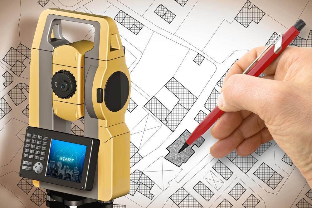
A boundary survey is a professional measurement and mapping of a property’s legal boundaries. Licensed land surveyors analyze historical records, property deeds, and physical land features to determine the exact location of property lines. They then mark those boundaries on the land and create a detailed survey document that shows the dimensions and limits of the property.
This process is important because property lines are not always obvious on the ground. Fences, tree lines, and natural features may not align perfectly with the legal boundaries described in property documents. Over time, misunderstandings about property lines can lead to disputes between neighbors or complications during real estate transactions.
In areas like Uvalde, where many properties include large tracts of land, ranch property, or rural acreage, accurate boundary information is especially important. A boundary survey provides clear documentation that defines the limits of ownership, helping prevent disagreements and legal challenges later.
Working with trusted boundary surveyors in Uvalde, TX, ensures the survey is completed accurately and meets Texas surveying standards.
When Do You Need a Boundary Survey?
Many property owners assume surveys are only required when buying land, but there are several situations where a boundary survey becomes essential. One of the most common times to obtain a survey is during a real estate transaction. Buyers often request a survey to confirm the size and boundaries of the property before finalizing a purchase.
Surveys are also important when building new structures. If you plan to construct a fence, driveway, barn, or home addition, knowing the exact location of your property lines helps ensure the structure stays within your property limits. This can prevent future conflicts with neighbors or violations of local regulations.
Another situation where surveys are valuable involves resolving boundary disputes. When neighboring property owners disagree about where a property line lies, a professional survey can provide clear documentation to settle the issue.
Land surveyors in Uvalde, TX, also assist property owners who are subdividing land or adjusting boundary lines between parcels. In each of these situations, a boundary survey helps provide accurate legal documentation that protects everyone involved.
How Is a Boundary Survey Performed?
Many people are curious about what happens during a boundary survey. The process typically begins with research. Surveyors examine property records, previous surveys, legal descriptions, and public documents to understand the property’s history and existing boundary descriptions.
After reviewing these records, the surveyor visits the property to perform field measurements. Using specialized equipment, they measure distances and angles between reference points to determine the precise location of property lines. These measurements help confirm or refine the boundaries described in the property documents.
Surveyors may also locate existing boundary markers or install new ones if necessary. These markers help physically identify the property corners and boundary lines.
Once the fieldwork is complete, the surveyor prepares a detailed map or survey plat. This document shows the property’s boundaries, dimensions, and relevant features such as buildings, easements, or neighboring parcels. Property owners can then use this document for legal, construction, or real estate purposes.
Professional boundary surveyors in Uvalde, TX, ensure that each step of this process meets the strict standards required by Texas law.
How Much Does a Boundary Survey Cost?
The cost of a boundary survey can vary depending on several factors. Property size is one of the biggest considerations. Larger parcels of land typically require more time and fieldwork, which can increase the overall cost.
The terrain and accessibility of the property can also influence the price. Rural properties outside Uvalde may include hills, wooded areas, or agricultural land that requires additional effort to measure accurately.
Another factor that affects cost is the availability of historical records. If previous surveys or property documents are readily available, the research portion of the survey may be simpler. However, when records are incomplete or unclear, additional time may be needed to establish accurate boundaries.
Although the price of a survey may vary, the value it provides often far outweighs the cost. A professionally completed boundary survey can prevent expensive legal disputes, construction errors, or property misunderstandings.
Smyth Surveyors works with property owners across the Uvalde area to provide accurate surveys that deliver long-term peace of mind.
Why Choose Professional Land Surveyors in Uvalde, TX?
Boundary surveys require a high level of technical expertise and legal knowledge. Licensed land surveyors must understand complex property laws, surveying principles, and advanced measurement techniques. Because property rights are involved, accuracy is critical.
Local knowledge also plays an important role. Land surveyors in Uvalde, TX, understand the unique characteristics of the region’s land records, property layouts, and terrain. This familiarity helps them interpret historical documents and perform fieldwork more effectively.
Smyth Surveyors is dedicated to providing reliable surveying services for property owners throughout the Uvalde area. Their team combines modern surveying technology with extensive experience to ensure every survey meets professional standards.
By working with qualified boundary surveyors, property owners can feel confident that their land boundaries are clearly defined and legally documented.
How Boundary Surveys Help Prevent Property Line Disputes
One of the most important benefits of a boundary survey is its ability to prevent conflicts between neighbors. Property line disputes can arise when fences, buildings, or landscaping extend beyond the true boundary of a property.
Without accurate information, these situations can quickly escalate into legal disagreements. A professional survey provides objective documentation that clarifies where each property begins and ends.
For property owners in Uvalde, this clarity is particularly valuable because many parcels of land include large areas or long-established boundaries that may not have been measured in decades. A modern survey provides updated information that reflects current property conditions.
When both parties have access to the same reliable data, it becomes much easier to resolve misunderstandings and maintain positive relationships between neighbors.
Understanding Your Property Starts with Accurate Surveying
Owning property is one of the most significant investments many people will ever make. Whether you are purchasing land, building on your property, or simply want to confirm your boundary lines, a professional boundary survey provides the clarity and protection you need. By working with experienced boundary surveyors in Uvalde, TX, property owners gain accurate documentation that supports legal transactions, construction planning, and long-term land management. Smyth Surveyors is committed to helping homeowners, ranch owners, and real estate investors understand their property boundaries with confidence. With the expertise of trusted land surveyors in Uvalde, TX, you can move forward knowing your property lines are clearly defined and protected for the future.
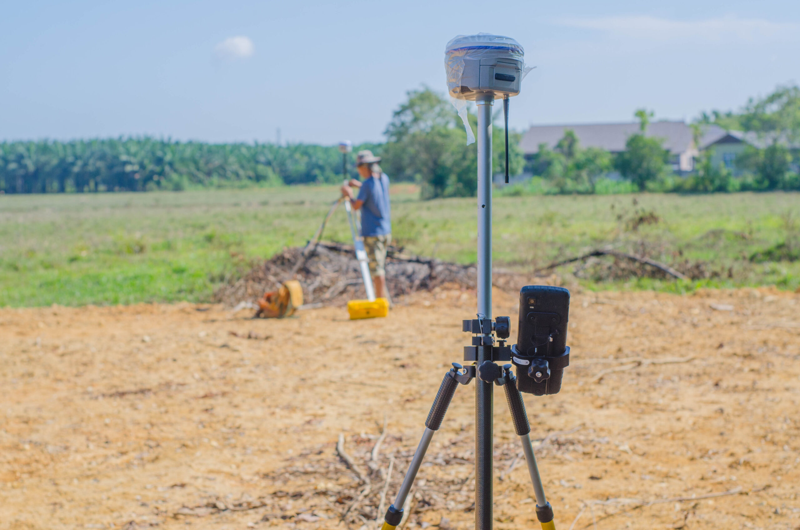
The land surveying industry has undergone significant changes in the past decade due to advances in technology. This transformation is especially evident in communities like Uvalde, TX, where land development, property sales, and agricultural uses depend heavily on accurate surveys. As the demand for real estate increases and infrastructure continues to expand, the need for reliable surveying methods grows stronger. Today, land surveyors in Uvalde, TX, are equipped with cutting-edge tools that make the process faster, more accurate, and more accessible than ever before.
The Evolution of Land Surveying Technologies
Traditional land surveying methods relied heavily on manual tools such as chains, compasses, and theodolites. While these tools were effective, they demanded a great deal of time, physical effort, and interpretation. Over the years, surveying has evolved into a data-driven profession that now incorporates tools such as GPS, drones, 3D scanning, and Geographic Information Systems (GIS).
Global Positioning System (GPS) technology, for instance, has revolutionized how land surveyors in Uvalde, TX, pinpoint exact coordinates. GPS allows surveyors to gather accurate location data in real time, reducing the margin of error and expediting the overall process. Meanwhile, GIS software helps store and analyze geographic data, giving surveyors the ability to model terrain, track property boundaries, and create interactive maps.
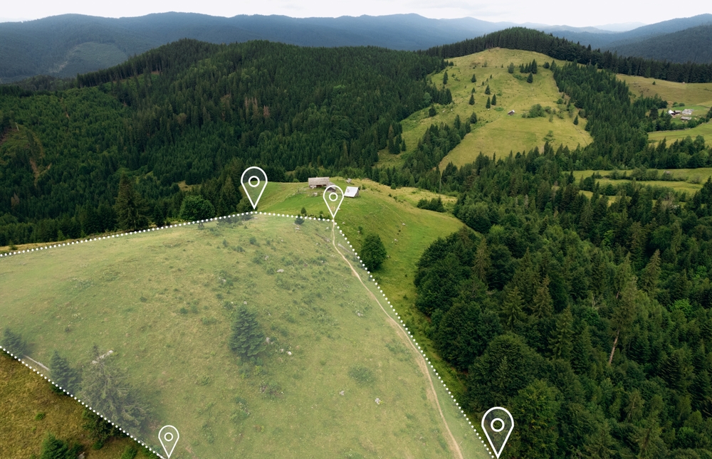
Another technological innovation making waves in Uvalde is drone-assisted surveying. Drones can cover large parcels of land in a fraction of the time it would take a traditional team on foot. They also capture high-resolution aerial imagery and provide topographic data that can be processed into detailed site models. This has become especially valuable in rural areas of Uvalde County where large tracts of land are common.
Impact on Property Development in Uvalde, TX
Technology-driven land surveying has had a measurable impact on the property market in Uvalde. Whether for residential, commercial, or agricultural purposes, landowners and developers benefit from more precise and efficient surveys. This is crucial for securing a mortgage survey, which is often required by lenders to verify property boundaries before issuing a loan. With the help of modern tools, surveyors can now deliver these surveys with quicker turnaround times and increased accuracy.
In a growing city like Uvalde, accurate property data is vital for planning utilities, zoning compliance, and environmental conservation. Advanced survey methods ensure that every inch of land is accounted for, allowing planners to make informed decisions about how to utilize space. For instance, digital terrain models generated through LiDAR and drone mapping can help determine flood zones, elevation changes, and soil conditions. These insights are invaluable when determining the feasibility of new construction projects.
Additionally, as real estate investment in Uvalde grows, buyers and sellers alike benefit from clear and reliable boundary information. Surveying technology helps prevent costly disputes by defining legal property lines with undeniable accuracy. This protects everyone involved in a transaction and ensures compliance with local laws and ordinances.
The Role of the Modern Land Surveyor in Uvalde, TX
As the tools of the trade change, so too does the role of the land surveyor. Today’s professionals must be both field experts and tech-savvy data analysts. In Uvalde, this means mastering drone piloting, GIS mapping, GPS operation, and advanced CAD (Computer-Aided Design) software. While the core responsibility remains the same – measuring and mapping land – the methods and expectations have dramatically evolved.
Modern surveyors in Uvalde must also stay up to date with changing regulations and technological advancements. They are often called upon to consult on zoning matters, assist with permit applications, and contribute to environmental assessments. Their findings influence real estate values, construction permits, and long-term development strategies. This multifaceted role adds immense value to the community and demands a new level of education and training.
Moreover, many land surveyors in Uvalde are partnering with engineering and architecture firms, integrating survey data into broader planning and design efforts. By aligning the technical precision of surveying with creative design, these partnerships contribute to smarter, safer, and more sustainable development.
Technological Advantages for Mortgage Surveys in Uvalde
Mortgage surveys are an essential part of the real estate process, especially when dealing with banks and title companies. In Uvalde, the speed and accuracy of this type of survey have improved thanks to advancements in technology. Traditional mortgage surveys could take several days, sometimes longer, depending on the terrain and scope. Today, using satellite data, aerial imagery, and mobile GPS tools, surveyors can complete these jobs in significantly less time.
This efficiency benefits not just the surveyors but also buyers, sellers, and financial institutions. Faster turnaround times can accelerate the closing process for real estate deals, making the Uvalde housing market more dynamic and accessible. The accuracy of modern tools also reduces the likelihood of issues during underwriting, providing clarity and confidence for all parties.
Another key benefit of technology is its ability to deliver visual evidence. Many modern survey reports now include 3D visualizations or drone imagery, which can be easily understood by clients who may not be familiar with technical drawings. These visuals offer peace of mind and help laypeople grasp the full scope of a property’s layout and limitations.
The Future Outlook for Surveying in Uvalde, TX
Looking ahead, the future of land surveying in Uvalde is poised to become even more integrated and intelligent. Emerging technologies such as artificial intelligence and machine learning are beginning to assist with data processing, allowing surveyors to analyze larger data sets with greater speed. These systems can detect patterns, flag anomalies, and automate repetitive tasks, allowing surveyors to focus more on planning and interpretation.
Additionally, the adoption of cloud computing is enabling real-time collaboration between surveyors, engineers, real estate agents, and local government officials. With cloud-based tools, stakeholders can access survey data from any device, anywhere. This level of accessibility fosters better communication and speeds up decision-making processes, particularly for large-scale development projects.
There is also growing interest in using augmented reality (AR) to overlay survey data onto real-world environments. Imagine walking a plot of land in Uvalde while viewing boundary lines, utility paths, and zoning information through AR glasses. While still in early stages, such tools could redefine how people interact with land data and make development planning more intuitive than ever.
As environmental regulations become stricter and sustainability rises in priority, technology will also play a role in ensuring compliance. Surveyors may be asked to monitor environmental impact, support conservation efforts, or assess land for renewable energy projects. With smart sensors and data analytics, these tasks can be conducted more thoroughly and responsibly.
Conclusion
Technology is reshaping land surveying in transformative ways, and communities like Uvalde, TX, stand to gain significantly from these changes. From the use of drones and GPS to the adoption of cloud platforms and artificial intelligence, the tools available to land surveyors have never been more powerful. These advances are not just technical upgrades; they translate directly into better outcomes for property owners, developers, and mortgage lenders alike.
The ability to deliver fast, accurate, and visually rich survey results empowers real estate transactions, supports responsible development, and reduces legal risk. In a dynamic and growing region like Uvalde, keeping pace with these innovations ensures that local properties are managed with precision and foresight. As the landscape of surveying continues to evolve, the partnership between technology and tradition will define the future of land use in Uvalde for decades to come.
Need Land Surveyors in Texas?
At Smyth Surveyors, Inc., we offer professional, official, and dependable land surveying in Texas. Our staff are all trained and licensed with our owner holding an L.S.L.S license. We can offer surveying for gas and oil well locations, pipeline right-of-way acquisition and construction alignment, determination of original survey boundaries, title boundary surveys, topographic surveys, and construction staking. If you are looking for a surveying company that has a prestigious record and an impeccable reputation look no further than Smyth Surveyors, Inc. Contact us today to speak with one of our friendly project managers and set up some time with us!
Land surveying plays a crucial role in shaping the development and sustainability of Concan, TX. Nestled along the Frio River in Uvalde County, Concan has long been a destination of natural beauty, attracting visitors and developers alike. With increased interest in both residential and commercial development, the importance of accurate and environmentally conscious surveying has never been greater. A qualified surveyor in Concan, TX helps property owners, developers, and government bodies understand the land’s boundaries, features, and legal characteristics.
The practice of land surveying provides the essential groundwork for construction projects, real estate transactions, and environmental assessments. Surveyors not only establish property lines but also evaluate topographic details, water drainage paths, and existing vegetation. In a sensitive region like Concan, TX, where the ecosystem depends on the balance between human activity and nature, surveying is foundational to responsible land use.
Additionally, the complexity of the Texas landscape, especially in the Hill Country where Concan is located, makes local expertise essential. A land surveyor familiar with Concan’s terrain and regulations ensures that property development adheres to both state laws and regional environmental guidelines. This local knowledge helps avoid costly mistakes and legal disputes, while also promoting more sustainable land management.
Environmental Challenges Unique to Concan, TX
Concan, TX sits in an ecologically diverse and fragile area. The region’s limestone bedrock, karst topography, and underground aquifers pose challenges for both development and conservation. One of the greatest environmental concerns in Concan is water management. The Frio River, a vital water source and recreational attraction, relies on a delicate balance of spring-fed flows and natural runoff. Any significant alteration to the land can disrupt this balance and lead to erosion, flooding, or water contamination.
Land surveying in Concan must account for these environmental risks. Surveyors are often tasked with evaluating slopes, identifying flood zones, and mapping out natural water flow patterns. These factors are critical when planning structures such as roads, homes, or commercial buildings. Improper development could interfere with groundwater recharge or direct runoff into vulnerable areas.
Another challenge involves preserving the region’s biodiversity. Native plants and animals are highly sensitive to changes in land use. Clear-cutting trees or altering elevation can destroy habitats and lead to long-term ecological harm. A conscientious surveyor in Concan, TX will use techniques that minimize disturbance and incorporate data that supports environmental protection.
In response to these concerns, sustainable surveying practices are becoming more widespread. This includes the use of non-invasive technologies like drone imaging, GPS mapping, and GIS systems to gather data without altering the terrain. These tools allow surveyors to create highly accurate models while preserving the natural features of the land.
How Land Surveying Supports Sustainable Development
Sustainable development seeks to meet the needs of the present without compromising future generations. In Concan, TX, this principle is especially relevant as the area continues to grow in popularity for tourism and real estate. Land surveying contributes to sustainability by guiding land use decisions that respect natural boundaries and ecological systems.
One way surveying supports sustainable practices is through comprehensive site assessments. These surveys analyze not only property lines but also soil stability, vegetation coverage, drainage systems, and access to utilities. By understanding these variables early in the planning process, developers can make smarter choices about where and how to build. This reduces the likelihood of environmental damage and improves long-term project success.
Surveyors in Concan, TX also play a role in regulatory compliance. Texas has specific environmental laws regarding development near rivers, floodplains, and protected habitats. Surveying data helps property owners obtain necessary permits and ensures that construction projects meet all environmental standards. This compliance is essential for minimizing legal risks and avoiding fines, but it also helps preserve the region’s natural beauty and resources.
Moreover, surveyors often collaborate with architects, engineers, and environmental consultants to design projects that are both efficient and ecologically responsible. For example, they may recommend site plans that avoid steep slopes or protect existing tree canopies. In doing so, they help create properties that blend more harmoniously with the landscape rather than dominating or damaging it.
The Role of Local Expertise in Concan, TX Surveying Projects
Hiring a land surveyor in Concan, TX offers distinct advantages, especially when it comes to understanding the local landscape and regulations. The Hill Country has unique geological and ecological characteristics that require careful consideration. Surveyors who work regularly in this region are better equipped to identify potential issues and recommend practical solutions that align with local expectations and state laws.
For instance, the proximity of a property to the Frio River can affect how land may be developed or subdivided. A local surveyor will know the applicable setback requirements, floodplain boundaries, and restrictions related to water access or usage. These factors are not always evident in a standard plat or map, but they can greatly influence a property’s value and usability.
In addition to environmental knowledge, a local surveyor is often familiar with community standards and planning processes. This familiarity streamlines approvals and reduces delays in project timelines. When challenges arise, such as disputes over boundary lines or easements, a surveyor with a track record in Concan can provide credible documentation that stands up in legal or administrative proceedings.
Moreover, local surveyors often maintain strong relationships with municipal officials, title companies, and contractors. These connections foster smoother communication and coordination throughout the life of a project. Whether it’s a new home site, a ranch expansion, or a commercial venture, having an experienced surveyor from Concan, TX can make a significant difference in the outcome.
Innovations and the Future of Sustainable Surveying
The field of land surveying is undergoing rapid transformation, driven by advances in technology and growing environmental awareness. In Concan, TX, these innovations are helping surveyors perform their work more accurately, efficiently, and sustainably. From satellite imaging to LiDAR scanning, the tools available today allow for detailed analysis with minimal environmental impact.
Drones, in particular, have revolutionized how surveyors gather data in rugged or sensitive terrain. With aerial mapping, surveyors can assess large areas quickly and with precision, reducing the need for ground disturbance. This is especially beneficial in environmentally sensitive zones near the Frio River or within conservation easements. The ability to capture high-resolution imagery also supports better decision-making and planning.
GIS (Geographic Information Systems) technology is another important development. GIS allows surveyors to integrate various data layers such as land use, soil type, vegetation, and hydrology. This holistic view supports sustainability by revealing how changes in one part of the land may affect others. In a region like Concan, where nature and development often overlap, this insight is invaluable.
In the coming years, sustainable surveying will likely involve even more integration with environmental science and community planning. Surveyors will be called upon not just to map boundaries, but to help shape the vision for how communities grow in harmony with their surroundings. As interest in Concan, TX continues to rise, this forward-thinking approach will be key to preserving what makes the area special.
Conclusion
Land surveying is a foundational element of both development and conservation in Concan, TX. As the region evolves, the role of the surveyor becomes increasingly important in balancing the needs of people and the environment. Accurate, thoughtful surveying supports responsible land use, safeguards natural resources, and ensures compliance with regulatory standards.
From identifying flood zones to protecting native habitats, surveyors in Concan contribute far more than maps. They offer guidance that helps communities grow in a way that respects the land’s inherent value. With the rise of new technologies and a greater emphasis on sustainability, land surveying continues to adapt, becoming an essential tool for shaping a future that is both vibrant and ecologically sound.
Need Land Surveyors in Texas?
At Smyth Surveyors, Inc., we offer professional, official, and dependable land surveying in Texas. Our staff are all trained and licensed with our owner holding an L.S.L.S license. We can offer surveying for gas and oil well locations, pipeline right-of-way acquisition and construction alignment, determination of original survey boundaries, title boundary surveys, topographic surveys, and construction staking. If you are looking for a surveying company that has a prestigious record and an impeccable reputation look no further than Smyth Surveyors, Inc. Contact us today to speak with one of our friendly project managers and set up some time with us!
In recent years, drone technology has revolutionized a wide array of industries, and property surveying is no exception. Traditionally, property surveys have involved painstaking manual measurements, time-consuming fieldwork, and a reliance on line-of-sight observations. While these methods have provided reliable data for decades, they also present limitations in terms of time, accuracy, and accessibility. Enter drones: compact, agile, and equipped with high-resolution imaging and GPS capabilities. The incorporation of drones into surveying practices is dramatically altering how land is measured, recorded, and analyzed.
For anyone considering a mortgage survey or seeking the expertise of a land surveyor in Uvalde, TX, understanding how drone technology is shaping this field is crucial. The benefits are not only transforming the industry for professionals but also delivering faster, more precise results for property owners, developers, and financial institutions alike.
A New Era of Accuracy in Property Surveys
Accuracy has always been at the core of any land survey. Precise measurements are essential to resolve property boundary disputes, assist with construction planning, and ensure legal clarity during real estate transactions. With the advent of drones, surveyors can now collect highly detailed geospatial data that surpasses traditional methods in both accuracy and efficiency.
Equipped with sophisticated sensors and cameras, drones are able to capture millimeter-level detail from above, generating three-dimensional terrain models and orthomosaic maps. These data outputs provide more comprehensive insights into a parcel of land, including contours, elevations, vegetation, and man-made structures. The ability to hover and adjust elevation means drones can measure otherwise inaccessible or dangerous areas, such as steep slopes or densely wooded lots.
This is particularly beneficial for regions like Uvalde, TX, where rural and semi-rural landscapes can make traditional land surveying more labor-intensive. A land surveyor in Uvalde, TX can now utilize drones to reduce the time spent on-site while achieving higher quality results.
Enhancing Efficiency and Reducing Turnaround Time
Speed is another game-changing factor drones bring to the table. Where traditional surveys might take several days or even weeks depending on the size and complexity of the property, drone-assisted surveys can often be completed in a matter of hours. Once airborne, a drone can cover large areas swiftly and efficiently, capturing a vast amount of data in a single flight session.
This increase in efficiency is especially important when it comes to meeting deadlines for a mortgage survey. In many real estate transactions, delays in survey results can stall the entire process. Buyers, sellers, lenders, and title companies all depend on timely and accurate information. Faster surveying through drones means quicker closings and reduced transaction costs.
Additionally, because drones reduce the need for multiple surveyors to physically walk a site, they also cut down on labor costs and logistical complexities. Surveying firms can serve more clients in less time, passing those savings and benefits along to property owners.
Expanding Surveying Capabilities in Complex Terrains
One of the greatest challenges for land surveyors has always been dealing with difficult or hazardous terrain. Mountainous regions, flood-prone areas, or heavily forested properties pose significant obstacles for conventional surveying tools. In Uvalde, TX, where the terrain can vary greatly across properties, drones offer a practical and safer solution.
Drones equipped with LiDAR (Light Detection and Ranging) systems can penetrate tree canopies to collect accurate ground elevation data, even in densely vegetated areas. LiDAR-equipped drones are particularly useful in forestry, environmental assessments, and construction planning, where topographical accuracy is essential.
In addition, drones can operate under conditions that might otherwise restrict human surveyors. For example, after a storm or natural disaster, a drone can safely fly over a damaged area to assess the impact and provide immediate data for insurance claims or emergency planning. The adaptability of drone technology makes it a vital tool for property surveying under a wide range of circumstances.
Supporting Better Decision-Making in Real Estate and Development
Drone-generated data is more than just numbers and coordinates; it forms the basis for informed decision-making. Developers, architects, and engineers can integrate drone surveys directly into their CAD software or GIS systems, allowing for precise planning and visualization. This level of integration enables faster design iterations and greater accuracy during construction.
For homebuyers or real estate investors seeking a mortgage survey, the insights from a drone-assisted survey can reveal potential issues such as drainage problems, boundary encroachments, or environmental risks. By catching these issues early, buyers can make more informed decisions and avoid costly surprises down the line.
In the Uvalde, TX region, where land development is steadily increasing, local authorities and planning departments are also leveraging drone surveys to assess land use, monitor construction compliance, and maintain up-to-date property records. This digital transformation in public and private sectors is enhancing transparency and contributing to smarter urban planning.
Legal and Regulatory Considerations
While drone technology offers numerous advantages, it also introduces new legal and regulatory considerations. In the United States, the Federal Aviation Administration (FAA) regulates the commercial use of drones. Surveying professionals must obtain proper licensing, follow flight restrictions, and ensure privacy compliance when operating drones over private property.
For landowners in Uvalde, TX seeking to hire a drone-capable land surveyor, it’s important to verify that the surveyor is FAA-certified and operates in accordance with both federal and state regulations. Ensuring that the collected data is legally admissible in court or for official documentation is another vital aspect.
Fortunately, the industry is rapidly professionalizing around drone use, and many established surveying firms have integrated these standards into their daily practices. When executed correctly, drone surveys meet or exceed traditional legal requirements for boundary definitions and property documentation.
Conclusion
The integration of drone technology into property surveying marks a pivotal advancement in how we understand, measure, and interact with land. By providing faster turnaround times, greater accuracy, and safer access to challenging terrains, drones are reshaping the expectations and capabilities of the surveying industry.
For residents and professionals in Uvalde, TX, this means enhanced access to high-quality surveying services. Whether you are applying for a mortgage survey or working with a land surveyor in Uvalde, TX to subdivide a lot or resolve a boundary dispute, drone-enhanced surveys offer a modern, efficient alternative to outdated methods.
As drone technology continues to evolve and regulatory frameworks mature, the role of drones in property surveys will only grow more prominent. Embracing this innovation not only benefits individual property owners and developers but also contributes to a broader transformation in how communities plan and grow. It’s clear that the skies are no longer the limit; they’re the future of land surveying.
Need Land Surveyors in Texas?
At Smyth Surveyors, Inc., we offer professional, official, and dependable land surveying in Texas. Our staff are all trained and licensed with our owner holding an L.S.L.S license. We can offer surveying for gas and oil well locations, pipeline right-of-way acquisition and construction alignment, determination of original survey boundaries, title boundary surveys, topographic surveys, and construction staking. If you are looking for a surveying company that has a prestigious record and an impeccable reputation look no further than Smyth Surveyors, Inc. Contact us today to speak with one of our friendly project managers and set up some time with us!