Land and boundary surveying represents one of the most critical professional services in real estate, construction, and property management. Boundary surveyors in Uvalde, TX play an essential role in determining exact property lines, establishing legal boundaries, and resolving disputes between neighboring property owners. These skilled professionals use advanced technology and decades of established surveying practices to create accurate maps and documentation that protect property rights and facilitate smooth real estate transactions.
The practice of surveying has existed for thousands of years, with evidence suggesting that ancient civilizations used surveying techniques to manage agricultural lands and construct monumental buildings. Today’s land surveyors in Uvalde, TX continue this tradition while incorporating cutting-edge technology such as GPS systems, laser measurement tools, and sophisticated software programs. This combination of traditional knowledge and modern innovation allows surveyors to deliver precise results that meet all legal and regulatory requirements.
When property owners in Uvalde, TX need to understand their land boundaries, they rely on professional surveyors to conduct thorough investigations. These investigations involve examining historical records, analyzing previous surveys, conducting field measurements, and creating detailed documentation that clearly establishes property lines. Whether you are planning a construction project, purchasing property, or dealing with a boundary dispute, understanding what boundary surveyors do can help you appreciate the value they bring to your transaction or project.
The Process of Professional Surveying
The surveying process begins long before surveyors step foot on a property. Boundary surveyors in Uvalde, TX first conduct extensive research into property records, deed documents, and historical surveys. This research phase is crucial because it provides the foundation for all subsequent field work. Surveyors examine courthouse records, title documents, and previous survey maps to understand how the property has been described and measured over time.
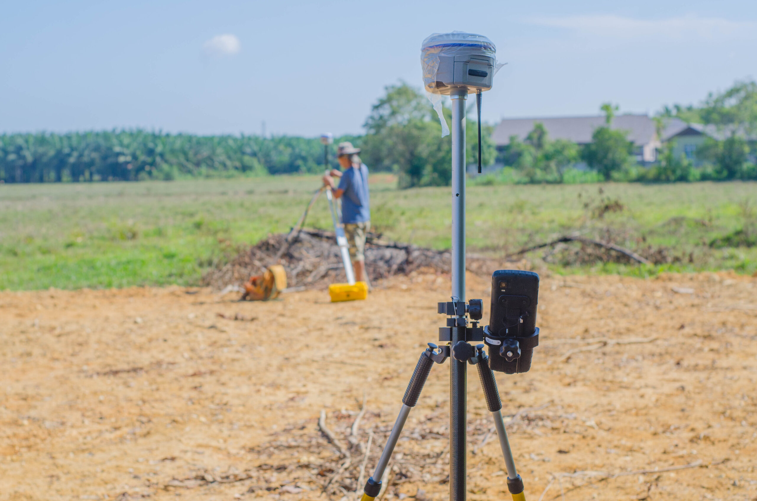
Once the research phase is complete, land surveyors in Uvalde, TX move into the field survey portion of the project. This phase involves physically visiting the property to take precise measurements and locate existing boundary markers such as corners, stakes, or monuments. Using modern GPS technology and laser measurement equipment, surveyors establish exact positions and distances between property boundaries. This fieldwork requires expertise, attention to detail, and understanding of how various environmental factors can affect measurement accuracy.
After completing field work, surveyors process all collected data using specialized software programs. This analysis phase involves comparing field measurements against historical records and determining the legal boundaries based on the property’s deed and local regulations. The surveyor must resolve any discrepancies between historical data and current field conditions, which sometimes requires additional research or legal interpretation.
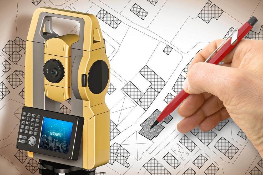
Finally, boundary surveyors in Uvalde, TX prepare comprehensive reports and maps documenting their findings. These documents become legal records that establish property boundaries and can be used in real estate transactions, construction projects, or legal proceedings. The final survey map includes all relevant measurements, boundary descriptions, and certification by the licensed surveyor, making it an official document recognized by courts and government agencies throughout Texas.
Why Boundary Surveyors Matter in Uvalde
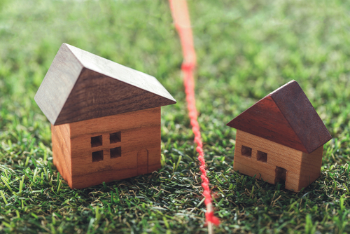
Property boundaries matter tremendously in Uvalde, TX and throughout the surrounding area. Disputes between neighbors often arise from unclear boundary lines, encroaching structures, or misunderstandings about where one property ends and another begins. Professional boundary surveyors in Uvalde, TX help prevent costly and stressful legal battles by establishing clear, documented boundaries that both parties can trust.
The importance of accurate surveying becomes especially apparent during real estate transactions. Buyers want to know exactly what land they are purchasing, and lenders require accurate surveys before approving mortgages. Land surveyors in Uvalde, TX provide the documentation that lenders and title companies need to ensure that property boundaries are clear and unencumbered. Without this professional verification, buyers risk purchasing property with boundary issues that could create problems for years to come.
For construction projects, accurate boundary surveys are absolutely essential. Contractors need to know exactly where they can build, and local zoning regulations often require specific setbacks from property lines. Boundary surveyors in Uvalde, TX ensure that construction projects comply with local ordinances and do not encroach on neighboring properties. This careful attention to boundaries protects contractors from legal liability and ensures that projects can proceed smoothly without complications.
Uvalde, TX features a diverse landscape with properties ranging from small residential lots in town to large rural tracts. Each type of property presents unique surveying challenges. Land surveyors in Uvalde, TX have experience working with all property types and understand local terrain, vegetation, and development patterns that can affect surveying work. Their familiarity with Uvalde’s specific conditions makes them invaluable partners for anyone dealing with property boundary issues.
Advanced Technology in Modern Surveying
Contemporary boundary surveyors in Uvalde, TX rely on technology that would have seemed impossible just a few decades ago. Global Positioning System technology allows surveyors to establish precise coordinates that are accurate to within inches or centimeters. This level of accuracy far exceeds what earlier surveying methods could achieve and provides a scientific foundation for all boundary determinations.
Laser measurement technology represents another significant advancement in surveying. These instruments allow surveyors to measure distances across difficult terrain and through vegetation with remarkable precision. Combined with traditional measuring techniques, laser technology enables land surveyors in Uvalde, TX to tackle complex surveying projects efficiently while maintaining the highest accuracy standards.
Drone technology is increasingly becoming part of the surveying toolkit. Aerial imagery captured by drones provides surveyors with comprehensive views of large properties and helps identify potential issues that might not be visible from ground level. This technology proves especially valuable for large rural properties in areas surrounding Uvalde, TX where traditional surveying methods might require significantly more time and resources.
Software programs designed specifically for surveying allow boundary surveyors in Uvalde, TX to process complex data sets and create accurate representations of property boundaries. These programs incorporate mathematical modeling, historical data analysis, and legal boundary interpretations to produce comprehensive survey maps and reports. The sophistication of modern surveying software ensures that results are consistent, reliable, and compliant with all applicable Texas surveying standards.
When to Hire Professional Surveyors
Property owners in Uvalde, TX should consider hiring boundary surveyors in several specific situations. If you are purchasing property, hiring a surveyor provides independent verification that boundary descriptions in the deed match actual ground conditions. This protection can prevent future disputes and clarify your actual property rights.
If you are experiencing a boundary dispute with a neighbor, land surveyors in Uvalde, TX can provide objective, professionally documented evidence about where the actual boundary line exists. Courts recognize surveyor testimony and documentation as authoritative evidence in property disputes, making professional surveying an important tool for resolving disagreements.
Before undertaking any significant construction or landscaping project, boundary surveyors in Uvalde, TX can verify that your plans comply with property line requirements and local zoning regulations. This verification prevents costly mistakes and legal complications down the road.
If you are dividing property or transferring ownership of a portion of your land, boundary surveyors in Uvalde, TX must create new survey maps showing the legal boundaries of each resulting parcel. These surveys ensure that each portion of property is properly documented and legally transferable.
Conclusion
Boundary surveyors in Uvalde, TX provide essential services that protect property rights, facilitate real estate transactions, and prevent costly disputes. Whether you are buying property, constructing a building, or managing a boundary question, professional land surveyors in Uvalde, TX bring expertise, advanced technology, and legal knowledge that make surveying services invaluable. Understanding what these professionals do and when to hire them helps ensure that your property matters are handled correctly and that your legal interests are fully protected.
Need Land Surveyors in Texas?
At Smyth Surveyors, Inc., we offer professional, official, and dependable land surveying in Texas. Our staff are all trained and licensed with our owner holding an L.S.L.S license. We can offer surveying for gas and oil well locations, pipeline right-of-way acquisition and construction alignment, determination of original survey boundaries, title boundary surveys, topographic surveys, and construction staking. If you are looking for a surveying company that has a prestigious record and an impeccable reputation look no further than Smyth Surveyors, Inc. Contact us today to speak with one of our friendly project managers and set up some time with us!
Buying or selling property is one of the most significant financial decisions many people make. In the excitement of negotiations, inspections, and closing timelines, one important step can sometimes be overlooked until late in the process: obtaining a professional land survey. A survey provides critical information about the exact boundaries and features of a property, helping everyone involved understand precisely what is being bought or sold.
For property owners and buyers in Uvalde and the surrounding Texas Hill Country, accurate surveying is especially important. Many properties in this region include large parcels of land, historic boundaries, or rural features that can make property lines less obvious. Working with experienced boundary surveyors in Uvalde, TX ensures that real estate transactions move forward with clarity and confidence. Professional land surveyors in Uvalde, TX, play a vital role in protecting property rights and preventing disputes that could arise long after the closing documents are signed.
What a Land Survey Reveals About a Property
A land survey provides an accurate map of a property’s legal boundaries and physical features. This document identifies the exact location of property lines, corner markers, and improvements such as houses, fences, driveways, and utility easements. It also highlights potential encroachments where structures or features may extend beyond the property line.
Without a survey, buyers and sellers often rely on assumptions about where property boundaries lie. Fences, tree lines, and natural landmarks are sometimes mistaken for boundary lines, even though they may not reflect the legal description of the property. Over time, these assumptions can lead to misunderstandings between neighbors or complications during real estate transactions.
By hiring qualified land surveyors in Uvalde, TX, property owners gain precise documentation that clearly defines the property’s dimensions and boundaries. This information provides peace of mind and helps both parties move forward with confidence during the transaction process.
Why Surveys Matter When Buying or Selling Property
When purchasing real estate, buyers want to know exactly what they are acquiring. A boundary survey confirms that the property described in the purchase agreement matches the actual land on the ground. This verification helps ensure there are no surprises once the transaction is complete.
For sellers, a survey can also be extremely valuable. Providing a current survey demonstrates transparency and helps answer questions about property lines before they become obstacles in the negotiation process. It also reduces the likelihood that unexpected issues will delay closing.
In Uvalde, where properties may include farmland, ranch land, or large residential lots, boundary clarity becomes even more important. Property lines can stretch across acres of land, making it difficult to visually determine where one property ends and another begins.
Boundary surveyors in Uvalde, TX, help resolve these uncertainties by carefully measuring the land and documenting the exact limits of ownership. This step protects both buyers and sellers from potential disputes that could arise after the sale.
Preventing Boundary Disputes Before They Start
One of the most common problems that surveys help prevent is property boundary disputes. These disputes can occur when neighboring property owners have different assumptions about where a boundary line exists. Sometimes a fence, driveway, or building may unintentionally cross into a neighboring parcel.
Without a professional survey, these issues may remain unnoticed until years later when a property changes hands or construction is planned. At that point, resolving the conflict can involve legal expenses, delays, or costly property adjustments.
A boundary survey performed by experienced land surveyors in Uvalde, TX, identifies these situations early in the process. If an encroachment exists, it can be addressed before the real estate transaction moves forward. Buyers and sellers can then make informed decisions about how to resolve the issue.
By establishing clear boundaries from the beginning, a survey helps maintain positive relationships between neighbors and prevents disputes that could otherwise create long-term complications.
Supporting Lenders, Title Companies, and Real Estate Professionals
Land surveys are not only valuable for buyers and sellers. They also play a critical role for lenders, title companies, and real estate professionals involved in the transaction. Financial institutions often require surveys to confirm that the property used as collateral for a loan is accurately described and free of boundary conflicts.
Title companies may review survey information to ensure there are no encroachments, easement conflicts, or other issues that could affect the ownership rights being transferred. If problems are identified during the survey process, they can often be resolved before the transaction reaches closing.
Real estate agents also benefit from the clarity that surveys provide. When agents understand the exact boundaries and features of a property, they can communicate more effectively with clients and answer questions with confidence.
Professional boundary surveyors in Uvalde, TX, provide the detailed documentation needed to support all of these parties throughout the real estate process. Their work helps ensure that each step of the transaction is based on accurate and reliable information.
The Value of Local Surveying Expertise
Surveying is both a technical science and a profession that requires deep knowledge of local land records, historical documents, and regional terrain. In areas like Uvalde County, many properties have histories that stretch back decades or even generations. Older property descriptions may reference natural landmarks, historical markers, or boundary lines established long before modern surveying technology existed.
Experienced land surveyors in Uvalde, TX, understand how to interpret these records and combine them with modern measurement techniques. Using advanced equipment, they perform precise field measurements that confirm the legal boundaries described in property documents.
Smyth Surveyors brings this combination of experience and technology to every project. Their team works carefully to ensure that each survey reflects the most accurate representation of the property. This attention to detail provides property owners with reliable documentation that stands up to legal and professional scrutiny.
Local expertise also allows surveyors to navigate the terrain and land characteristics common in the region. From rural acreage to residential neighborhoods in and around Uvalde, experienced surveyors understand the unique factors that can influence property boundaries.
Protecting Your Investment Through Accurate Surveying
Real estate transactions involve significant financial commitments and long-term investments. Whether purchasing a family home, farmland, or investment property, understanding the exact boundaries of the land is essential. A professional survey provides the clarity needed to avoid misunderstandings and protect property rights.
Working with qualified boundary surveyors in Uvalde, TX, ensures that property boundaries are clearly defined and properly documented. This step helps buyers make informed decisions, allows sellers to provide accurate information, and supports the many professionals involved in completing a successful real estate transaction.
Smyth Surveyors is dedicated to helping property owners throughout the Uvalde area understand their land with confidence. By combining modern surveying technology with deep knowledge of local property records, their team delivers reliable results that support smooth real estate transactions. When property boundaries are clearly established, everyone involved can move forward with certainty, knowing that the land being bought or sold is accurately defined and protected for years to come.
Owning property in Uvalde, Texas comes with many advantages. The region offers wide-open land, scenic Hill Country views, and a strong sense of community. Whether you own a home in town, manage farmland outside the city limits, or are preparing to purchase rural acreage nearby, understanding your property boundaries is essential. One of the most reliable ways to establish those boundaries is through a professional boundary survey.
Many property owners have questions about surveys. They may wonder when a survey is necessary, how the process works, or why it matters when buying or selling land. Working with experienced boundary surveyors in Uvalde, TX, helps property owners avoid costly disputes and gain confidence in the exact limits of their land. In this guide, we answer some of the most common questions people ask about boundary surveys and explain why hiring qualified land surveyors in Uvalde, TX, is such an important step in protecting your property rights.
What Is a Boundary Survey and Why Is It Important?
A boundary survey is a professional measurement and mapping of a property’s legal boundaries. Licensed land surveyors analyze historical records, property deeds, and physical land features to determine the exact location of property lines. They then mark those boundaries on the land and create a detailed survey document that shows the dimensions and limits of the property.
This process is important because property lines are not always obvious on the ground. Fences, tree lines, and natural features may not align perfectly with the legal boundaries described in property documents. Over time, misunderstandings about property lines can lead to disputes between neighbors or complications during real estate transactions.
In areas like Uvalde, where many properties include large tracts of land, ranch property, or rural acreage, accurate boundary information is especially important. A boundary survey provides clear documentation that defines the limits of ownership, helping prevent disagreements and legal challenges later.
Working with trusted boundary surveyors in Uvalde, TX, ensures the survey is completed accurately and meets Texas surveying standards.
When Do You Need a Boundary Survey?
Many property owners assume surveys are only required when buying land, but there are several situations where a boundary survey becomes essential. One of the most common times to obtain a survey is during a real estate transaction. Buyers often request a survey to confirm the size and boundaries of the property before finalizing a purchase.
Surveys are also important when building new structures. If you plan to construct a fence, driveway, barn, or home addition, knowing the exact location of your property lines helps ensure the structure stays within your property limits. This can prevent future conflicts with neighbors or violations of local regulations.
Another situation where surveys are valuable involves resolving boundary disputes. When neighboring property owners disagree about where a property line lies, a professional survey can provide clear documentation to settle the issue.
Land surveyors in Uvalde, TX, also assist property owners who are subdividing land or adjusting boundary lines between parcels. In each of these situations, a boundary survey helps provide accurate legal documentation that protects everyone involved.
How Is a Boundary Survey Performed?
Many people are curious about what happens during a boundary survey. The process typically begins with research. Surveyors examine property records, previous surveys, legal descriptions, and public documents to understand the property’s history and existing boundary descriptions.
After reviewing these records, the surveyor visits the property to perform field measurements. Using specialized equipment, they measure distances and angles between reference points to determine the precise location of property lines. These measurements help confirm or refine the boundaries described in the property documents.
Surveyors may also locate existing boundary markers or install new ones if necessary. These markers help physically identify the property corners and boundary lines.
Once the fieldwork is complete, the surveyor prepares a detailed map or survey plat. This document shows the property’s boundaries, dimensions, and relevant features such as buildings, easements, or neighboring parcels. Property owners can then use this document for legal, construction, or real estate purposes.
Professional boundary surveyors in Uvalde, TX, ensure that each step of this process meets the strict standards required by Texas law.
How Much Does a Boundary Survey Cost?
The cost of a boundary survey can vary depending on several factors. Property size is one of the biggest considerations. Larger parcels of land typically require more time and fieldwork, which can increase the overall cost.
The terrain and accessibility of the property can also influence the price. Rural properties outside Uvalde may include hills, wooded areas, or agricultural land that requires additional effort to measure accurately.
Another factor that affects cost is the availability of historical records. If previous surveys or property documents are readily available, the research portion of the survey may be simpler. However, when records are incomplete or unclear, additional time may be needed to establish accurate boundaries.
Although the price of a survey may vary, the value it provides often far outweighs the cost. A professionally completed boundary survey can prevent expensive legal disputes, construction errors, or property misunderstandings.
Smyth Surveyors works with property owners across the Uvalde area to provide accurate surveys that deliver long-term peace of mind.
Why Choose Professional Land Surveyors in Uvalde, TX?
Boundary surveys require a high level of technical expertise and legal knowledge. Licensed land surveyors must understand complex property laws, surveying principles, and advanced measurement techniques. Because property rights are involved, accuracy is critical.
Local knowledge also plays an important role. Land surveyors in Uvalde, TX, understand the unique characteristics of the region’s land records, property layouts, and terrain. This familiarity helps them interpret historical documents and perform fieldwork more effectively.
Smyth Surveyors is dedicated to providing reliable surveying services for property owners throughout the Uvalde area. Their team combines modern surveying technology with extensive experience to ensure every survey meets professional standards.
By working with qualified boundary surveyors, property owners can feel confident that their land boundaries are clearly defined and legally documented.
How Boundary Surveys Help Prevent Property Line Disputes
One of the most important benefits of a boundary survey is its ability to prevent conflicts between neighbors. Property line disputes can arise when fences, buildings, or landscaping extend beyond the true boundary of a property.
Without accurate information, these situations can quickly escalate into legal disagreements. A professional survey provides objective documentation that clarifies where each property begins and ends.
For property owners in Uvalde, this clarity is particularly valuable because many parcels of land include large areas or long-established boundaries that may not have been measured in decades. A modern survey provides updated information that reflects current property conditions.
When both parties have access to the same reliable data, it becomes much easier to resolve misunderstandings and maintain positive relationships between neighbors.
Understanding Your Property Starts with Accurate Surveying
Owning property is one of the most significant investments many people will ever make. Whether you are purchasing land, building on your property, or simply want to confirm your boundary lines, a professional boundary survey provides the clarity and protection you need. By working with experienced boundary surveyors in Uvalde, TX, property owners gain accurate documentation that supports legal transactions, construction planning, and long-term land management. Smyth Surveyors is committed to helping homeowners, ranch owners, and real estate investors understand their property boundaries with confidence. With the expertise of trusted land surveyors in Uvalde, TX, you can move forward knowing your property lines are clearly defined and protected for the future.
The land surveying industry has undergone significant changes in the past decade due to advances in technology. This transformation is especially evident in communities like Uvalde, TX, where land development, property sales, and agricultural uses depend heavily on accurate surveys. As the demand for real estate increases and infrastructure continues to expand, the need for reliable surveying methods grows stronger. Today, land surveyors in Uvalde, TX, are equipped with cutting-edge tools that make the process faster, more accurate, and more accessible than ever before.
The Evolution of Land Surveying Technologies
Traditional land surveying methods relied heavily on manual tools such as chains, compasses, and theodolites. While these tools were effective, they demanded a great deal of time, physical effort, and interpretation. Over the years, surveying has evolved into a data-driven profession that now incorporates tools such as GPS, drones, 3D scanning, and Geographic Information Systems (GIS).
Global Positioning System (GPS) technology, for instance, has revolutionized how land surveyors in Uvalde, TX, pinpoint exact coordinates. GPS allows surveyors to gather accurate location data in real time, reducing the margin of error and expediting the overall process. Meanwhile, GIS software helps store and analyze geographic data, giving surveyors the ability to model terrain, track property boundaries, and create interactive maps.
Another technological innovation making waves in Uvalde is drone-assisted surveying. Drones can cover large parcels of land in a fraction of the time it would take a traditional team on foot. They also capture high-resolution aerial imagery and provide topographic data that can be processed into detailed site models. This has become especially valuable in rural areas of Uvalde County where large tracts of land are common.
Impact on Property Development in Uvalde, TX
Technology-driven land surveying has had a measurable impact on the property market in Uvalde. Whether for residential, commercial, or agricultural purposes, landowners and developers benefit from more precise and efficient surveys. This is crucial for securing a mortgage survey, which is often required by lenders to verify property boundaries before issuing a loan. With the help of modern tools, surveyors can now deliver these surveys with quicker turnaround times and increased accuracy.
In a growing city like Uvalde, accurate property data is vital for planning utilities, zoning compliance, and environmental conservation. Advanced survey methods ensure that every inch of land is accounted for, allowing planners to make informed decisions about how to utilize space. For instance, digital terrain models generated through LiDAR and drone mapping can help determine flood zones, elevation changes, and soil conditions. These insights are invaluable when determining the feasibility of new construction projects.
Additionally, as real estate investment in Uvalde grows, buyers and sellers alike benefit from clear and reliable boundary information. Surveying technology helps prevent costly disputes by defining legal property lines with undeniable accuracy. This protects everyone involved in a transaction and ensures compliance with local laws and ordinances.
The Role of the Modern Land Surveyor in Uvalde, TX
As the tools of the trade change, so too does the role of the land surveyor. Today’s professionals must be both field experts and tech-savvy data analysts. In Uvalde, this means mastering drone piloting, GIS mapping, GPS operation, and advanced CAD (Computer-Aided Design) software. While the core responsibility remains the same – measuring and mapping land – the methods and expectations have dramatically evolved.
Modern surveyors in Uvalde must also stay up to date with changing regulations and technological advancements. They are often called upon to consult on zoning matters, assist with permit applications, and contribute to environmental assessments. Their findings influence real estate values, construction permits, and long-term development strategies. This multifaceted role adds immense value to the community and demands a new level of education and training.
Moreover, many land surveyors in Uvalde are partnering with engineering and architecture firms, integrating survey data into broader planning and design efforts. By aligning the technical precision of surveying with creative design, these partnerships contribute to smarter, safer, and more sustainable development.
Technological Advantages for Mortgage Surveys in Uvalde
Mortgage surveys are an essential part of the real estate process, especially when dealing with banks and title companies. In Uvalde, the speed and accuracy of this type of survey have improved thanks to advancements in technology. Traditional mortgage surveys could take several days, sometimes longer, depending on the terrain and scope. Today, using satellite data, aerial imagery, and mobile GPS tools, surveyors can complete these jobs in significantly less time.
This efficiency benefits not just the surveyors but also buyers, sellers, and financial institutions. Faster turnaround times can accelerate the closing process for real estate deals, making the Uvalde housing market more dynamic and accessible. The accuracy of modern tools also reduces the likelihood of issues during underwriting, providing clarity and confidence for all parties.
Another key benefit of technology is its ability to deliver visual evidence. Many modern survey reports now include 3D visualizations or drone imagery, which can be easily understood by clients who may not be familiar with technical drawings. These visuals offer peace of mind and help laypeople grasp the full scope of a property’s layout and limitations.
The Future Outlook for Surveying in Uvalde, TX
Looking ahead, the future of land surveying in Uvalde is poised to become even more integrated and intelligent. Emerging technologies such as artificial intelligence and machine learning are beginning to assist with data processing, allowing surveyors to analyze larger data sets with greater speed. These systems can detect patterns, flag anomalies, and automate repetitive tasks, allowing surveyors to focus more on planning and interpretation.
Additionally, the adoption of cloud computing is enabling real-time collaboration between surveyors, engineers, real estate agents, and local government officials. With cloud-based tools, stakeholders can access survey data from any device, anywhere. This level of accessibility fosters better communication and speeds up decision-making processes, particularly for large-scale development projects.
There is also growing interest in using augmented reality (AR) to overlay survey data onto real-world environments. Imagine walking a plot of land in Uvalde while viewing boundary lines, utility paths, and zoning information through AR glasses. While still in early stages, such tools could redefine how people interact with land data and make development planning more intuitive than ever.
As environmental regulations become stricter and sustainability rises in priority, technology will also play a role in ensuring compliance. Surveyors may be asked to monitor environmental impact, support conservation efforts, or assess land for renewable energy projects. With smart sensors and data analytics, these tasks can be conducted more thoroughly and responsibly.
Conclusion
Technology is reshaping land surveying in transformative ways, and communities like Uvalde, TX, stand to gain significantly from these changes. From the use of drones and GPS to the adoption of cloud platforms and artificial intelligence, the tools available to land surveyors have never been more powerful. These advances are not just technical upgrades; they translate directly into better outcomes for property owners, developers, and mortgage lenders alike.
The ability to deliver fast, accurate, and visually rich survey results empowers real estate transactions, supports responsible development, and reduces legal risk. In a dynamic and growing region like Uvalde, keeping pace with these innovations ensures that local properties are managed with precision and foresight. As the landscape of surveying continues to evolve, the partnership between technology and tradition will define the future of land use in Uvalde for decades to come.
Need Land Surveyors in Texas?
At Smyth Surveyors, Inc., we offer professional, official, and dependable land surveying in Texas. Our staff are all trained and licensed with our owner holding an L.S.L.S license. We can offer surveying for gas and oil well locations, pipeline right-of-way acquisition and construction alignment, determination of original survey boundaries, title boundary surveys, topographic surveys, and construction staking. If you are looking for a surveying company that has a prestigious record and an impeccable reputation look no further than Smyth Surveyors, Inc. Contact us today to speak with one of our friendly project managers and set up some time with us!
A Flood Elevation Certificate is a crucial document for property owners in flood-prone areas. It provides detailed information about a building’s elevation relative to the estimated height floodwaters could reach during a major flood. Specifically, this certificate helps determine insurance rates under the National Flood Insurance Program (NFIP). It also ensures compliance with local floodplain management ordinances.
In Texas, and particularly in smaller communities like La Pryor, understanding the role of this certificate is essential. The state experiences frequent extreme weather events, including hurricanes and heavy rainstorms that can lead to sudden flooding. Therefore, property owners in La Pryor, TX, must be aware of how floodplain regulations affect them and the value of a Flood Elevation Certificate.
While the certificate is not always required by law, it becomes necessary in several circumstances, including when applying for federal flood insurance or when constructing new buildings in flood zones. Knowing whether your property requires one can save you money and prevent future legal or financial complications.
Why La Pryor, TX Residents Need a Flood Elevation Certificate
La Pryor is a small community in Zavala County, Texas. While it may not seem like an area prone to large-scale flooding, its geography and proximity to the Nueces River and various drainage channels mean that it is not immune to flood risks. In recent years, Texas has seen an increase in both the frequency and severity of flood events, making it more important for residents of rural towns like La Pryor to prepare adequately.
A Flood Elevation Certificate is especially relevant if your property lies within a Special Flood Hazard Area (SFHA), as designated by the Federal Emergency Management Agency (FEMA). Mortgage lenders often require flood insurance for properties in SFHAs, and an Elevation Certificate helps determine the appropriate level of coverage. Without one, you might be classified as high-risk and charged significantly higher premiums, even if your home is relatively safe from flooding.
Local officials in La Pryor use Elevation Certificates as part of their building permit processes. When constructing a new home or significantly remodeling an existing one, you may be asked to submit a certificate to verify that your property meets floodplain management standards. This ensures that buildings are elevated above the base flood elevation, minimizing the potential for flood damage.
How a Flood Elevation Certificate Affects Insurance Costs
One of the most immediate financial impacts of a Flood Elevation Certificate is its influence on flood insurance premiums. The NFIP, administered by FEMA, bases its rates in part on the elevation data provided in this certificate. The lower your property sits compared to the base flood elevation, the higher your insurance costs will likely be.
Conversely, if your property is elevated above the expected flood level, having a certificate can demonstrate reduced risk and result in lower insurance premiums. This is particularly important in Texas, where extreme weather can lead to fast-changing floodplain maps and fluctuating insurance rates. For residents of La Pryor, TX, the savings can be significant over the lifetime of property ownership.
Insurance agents and NFIP providers use the information on the Elevation Certificate to assess risk more accurately. This includes details such as the building’s location, construction type, foundation, and the elevation of the lowest floor. With this data, underwriters can classify the property properly, avoiding worst-case risk assumptions that lead to inflated premiums.
The savings on insurance can often outweigh the one-time cost of obtaining the certificate, which usually involves hiring a licensed land surveyor or engineer. For homeowners in La Pryor trying to manage living costs and protect their investments, getting a certificate is often a wise financial move.
What Information is Included in a Flood Elevation Certificate
A Flood Elevation Certificate is a standardized document issued by FEMA. It includes several pieces of important data that inform both floodplain management and insurance decisions. In Texas, and especially in rural towns like La Pryor, these details can be the difference between affordable and costly insurance or compliant and non-compliant construction.
The certificate includes basic property information, such as the address and legal description. It then outlines the flood zone in which the property lies according to FEMA’s Flood Insurance Rate Map (FIRM). This designation affects insurance requirements and development rules.
Next, it provides specific elevation data for the building. This includes the elevation of the lowest floor, including basements or enclosures, and the height of equipment like HVAC units that could be damaged in a flood. These measurements must be taken and verified by a qualified surveyor or engineer to ensure accuracy.
The document also describes the building’s type of construction and foundation system. For example, whether it is slab-on-grade or elevated on piers, which can drastically affect flood resilience. Additionally, the certificate includes photographs of the structure, providing visual documentation of its elevation and surrounding features.
This detailed data supports the assessment of flood risk and can be shared with multiple stakeholders: homeowners, insurers, local officials, and emergency planners. For La Pryor residents, having this information on file helps create a clearer picture of their flood exposure and informs future decisions.
Steps to Obtain a Flood Elevation Certificate in La Pryor, TX
Securing a Flood Elevation Certificate in La Pryor involves a few key steps, typically starting with determining whether you need one. If your property is in a FEMA-designated flood zone, or if your lender requires flood insurance, you will likely need to provide this documentation.
The process begins by hiring a licensed professional, such as a surveyor, architect, or engineer, to perform the necessary elevation measurements. They will visit your property, conduct a field survey, and complete the FEMA form with the required data. In Texas, only professionals with state certification can provide official Elevation Certificates, ensuring accuracy and compliance with federal standards.
Once the form is completed, it should be submitted to your local floodplain administrator or building department. In La Pryor, this may be handled by the county office or a regional authority responsible for land development and zoning. They will review the certificate to confirm that your building meets local floodplain management rules.
If you are purchasing flood insurance, your insurance agent will also require a copy. Be sure to retain the certificate in your personal records, as it may be useful for future claims, permit applications, or when selling your property.
Property owners can also check with the previous owner or the local building department to see if a certificate already exists. This can save time and money, particularly if no major changes have been made to the building or its elevation since the certificate was issued.
Conclusion
In La Pryor, TX, a Flood Elevation Certificate is more than just a technical document. It is a vital tool that protects your investment, ensures compliance with floodplain regulations, and can significantly reduce your flood insurance premiums. Given the unpredictable nature of Texas weather and the potential for sudden floods, understanding and obtaining this certificate should be a priority for all property owners in designated flood zones.
Whether you are buying a home, building a new structure, or simply trying to reduce insurance costs, a Flood Elevation Certificate provides the clarity and data needed to make informed decisions. It supports long-term resilience and financial planning in a region where preparedness can make all the difference.
By investing in this essential document, residents of La Pryor not only safeguard their homes but also contribute to a community-wide effort to mitigate flood risk and protect local infrastructure. With proper planning and documentation, navigating the challenges of floodplain management in Texas becomes a much more manageable task.
Need Land Surveyors in Texas?
At Smyth Surveyors, Inc., we offer professional, official, and dependable land surveying in Texas. Our staff are all trained and licensed with our owner holding an L.S.L.S license. We can offer surveying for gas and oil well locations, pipeline right-of-way acquisition and construction alignment, determination of original survey boundaries, title boundary surveys, topographic surveys, and construction staking. If you are looking for a surveying company that has a prestigious record and an impeccable reputation look no further than Smyth Surveyors, Inc. Contact us today to speak with one of our friendly project managers and set up some time with us!