Understanding Flood Zones: What La Pryor Residents Need to Know
If you own property in La Pryor, TX, or are considering buying a home in Zavala County, understanding flood zones is one of the most important steps you can take to protect your investment and your family. South Texas is no stranger to heavy rainfall events and flash flooding, and even a small community like La Pryor can face significant flood exposure depending on where a structure sits relative to local waterways and drainage patterns.
This guide breaks down what flood zones mean, why a Flood Elevation Certificate matters, and what steps residents can take to stay informed and financially protected.
What Are Flood Zones and How Are They Determined?
Flood maps are one of the key tools that communities use to identify which areas carry the highest risk of flooding. FEMA maintains and updates this data through flood maps and risk assessments. Flood maps show how likely it is for an area to flood, and any place with a 1% chance or higher chance of experiencing a flood each year is considered high risk. Properties in those areas carry at least a one-in-four chance of flooding over the course of a 30-year mortgage.
Importantly, floods do not follow city limits or property lines. Using a flood map, you can see the relationship between your property and the areas with the highest risk of flooding. There is no such thing as a “no-risk zone,” but some areas have a lower or moderate risk.
In Texas, flood zone designations that begin with the letters A or V are considered Special Flood Hazard Areas (SFHAs). Properties in Zone X are not subject to the federal mandate for flood insurance, but lenders may still require coverage, and it is often recommended given Texas’s flood history.
The FEMA Flood Map Service Center (MSC) is the official public source for flood hazard information produced in support of the National Flood Insurance Program (NFIP). Residents can use the MSC to find their official flood map, access a range of other flood hazard products, and better understand their flood risk. For La Pryor, TX residents, this is the most reliable starting point for understanding your property’s flood zone classification.
The Unique Flood Risk Landscape of La Pryor, TX
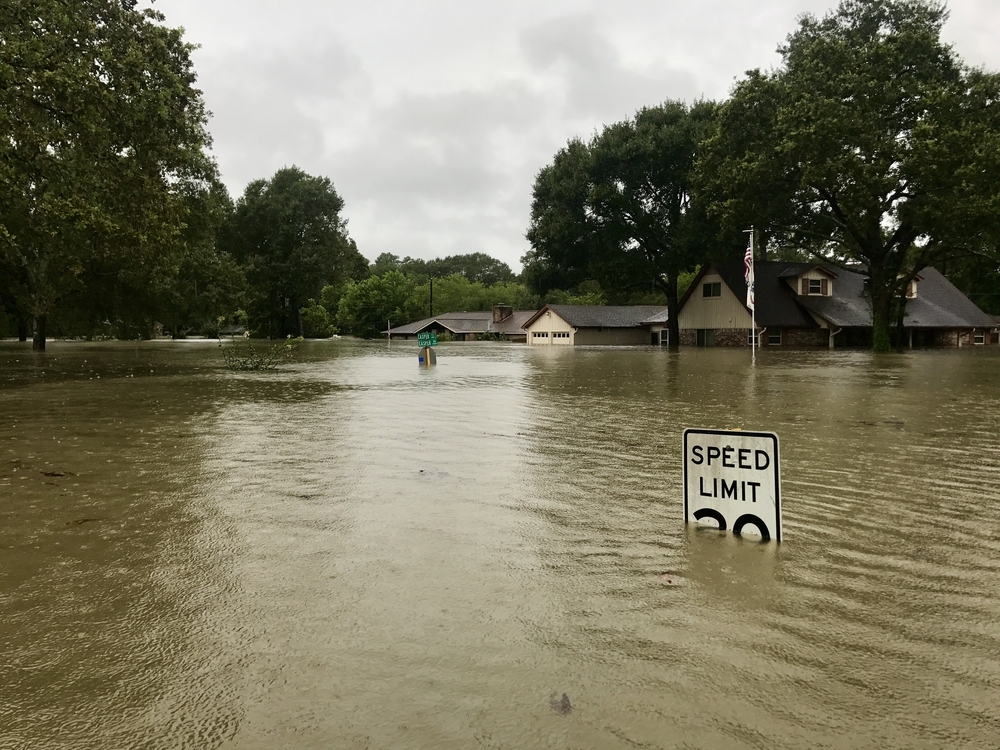
La Pryor is a census-designated place in Zavala County, Texas, situated at an elevation of 745 feet above sea level. While its relatively modest elevation places it in the South Texas Plains, the region is crossed by waterways that can rise dramatically during heavy rain events. The Nueces River runs through Zavala County, and the Averhoff Reservoir, located on the Nueces River about 10 miles north of Crystal City, was constructed in 1948 in part for flood control purposes.
The Nueces River originates on the Edwards Plateau in Central Texas. The Sabinal, Atascosa, Leona, and Frio Rivers and their numerous tributaries all feed the Nueces on its journey south. This river system crosses through the South Texas Plains ecoregion, the same landscape that encompasses La Pryor and the surrounding Zavala County area.
South Central Texas has experienced repeated catastrophic flooding events, with record flows recorded along the Nueces River during major storm cycles. These events have caused hundreds of millions of dollars in property losses and claimed lives, often because motorists drove through flooded low-water crossings. For La Pryor, TX residents, this regional history is a reminder that flood risk is real and must be taken seriously regardless of how a property is currently zoned.
What Is a Flood Elevation Certificate and Why Do You Need One?
A Flood Elevation Certificate is a critical document that directly affects your flood insurance premiums and your ability to comply with local building requirements. A FEMA Elevation Certificate is an official document that records the elevation of your building and its lowest floor in relation to the Base Flood Elevation (BFE), which is the anticipated height that floodwaters will reach during a 100-year flood event. This detailed elevation information is vital for determining flood risk and, consequently, flood insurance premiums for properties located in communities participating in the NFIP.
In Texas, many communities participate in the NFIP, requiring property owners in designated flood zones to obtain flood insurance. The cost of this insurance is directly influenced by the information provided on the elevation certificate. Common terms encountered on an elevation certificate include Base Flood Elevation (BFE), Lowest Adjacent Grade (LAG), Highest Adjacent Grade (HAG), Flood Insurance Rate Map (FIRM), and National Flood Insurance Program (NFIP).
Elevation Certificates show where the building is, the height of its lowest floor compared to the Base Flood Elevation, and other details about the building and its flood zone. An Elevation Certificate can help property owners in high-risk flood areas understand what actions could lower their flood risk and ensure their properties follow local floodplain management ordinances.
The Elevation Certificate is also used to support a request for a Letter of Map Amendment (LOMA) or a Letter of Map Revision based on fill (LOMR-F). It is required to properly rate post-FIRM buildings for flood insurance in high-risk zones such as Zones AE, AH, A with BFE, VE, and others.
How to Obtain a Flood Elevation Certificate in La Pryor, TX
Getting a Flood Elevation Certificate in La Pryor, TX does not have to be a complicated process. There are several ways to obtain an elevation certificate. You can contact your local floodplain manager, ask the sellers when buying a property, check with the developer or builder of the home, look through the property deed, or hire a licensed land surveyor, professional engineer, or certified architect who is authorized by law to certify elevation information.
In Texas, the state does not keep elevation certificates on file, but your local floodplain administrator should have them. You can check a listing of floodplain administrators and their contact information through the Texas Water Development Board.
Without an accurate Elevation Certificate, property owners in Special Flood Hazard Areas may pay higher-than-necessary insurance rates or face hurdles in securing the permits required for construction. This makes obtaining a Flood Elevation Certificate one of the smartest financial moves a La Pryor, TX property owner can make, especially for those located near drainage channels, creeks, or low-lying terrain.
For certain buildings in a high-risk zone, an Elevation Certificate may be required if the flood insurance policy is written through a federally regulated insurance lender such as the NFIP. Private insurers do not typically require ECs for any zone. Having a copy of your EC when you contact an insurance agent to purchase flood insurance is strongly recommended if you live in a high-risk area.
How a Flood Elevation Certificate Can Lower Your Insurance Costs
One of the most practical benefits of obtaining a Flood Elevation Certificate is its potential to reduce your flood insurance premiums, sometimes by a significant amount. Property owners may choose to provide an Elevation Certificate and submit it to their agent to see if it will lower their insurance cost. Insurance agents are responsible for reviewing the certificate annually and determining the best rate and coverage for their clients each year.
Discounts are based on characteristics such as foundation type, first floor height, and flood openings. If your home sits above the Base Flood Elevation, the Elevation Certificate provides the documentation needed to demonstrate that reduced risk to your insurer. In some cases, a Flood Elevation Certificate can even support a formal challenge to your flood zone classification.
This precision is especially valuable when challenging a high-risk flood zone classification or seeking to lower prohibitive flood insurance premiums. For residents of La Pryor, TX who feel their property has been incorrectly classified in a higher-risk zone, the Elevation Certificate is the essential first step in initiating that appeal process through FEMA.
Some communities participate in FEMA’s voluntary incentive program called the Community Rating System (CRS), which recognizes and encourages floodplain management activities that exceed minimum NFIP requirements. Participation in this program can reduce flood insurance premiums for property owners throughout the community. Residents should check whether Zavala County or La Pryor participates in the CRS, as this can provide additional savings on top of what an individual Elevation Certificate already offers.
Conclusion
For residents and property owners in La Pryor, TX, understanding flood zones and securing a Flood Elevation Certificate are foundational steps toward financial protection and long-term peace of mind. The Nueces River watershed and South Texas weather patterns create real flood exposure in this region, and being unprepared can lead to costly consequences. Whether you are buying a home, building a new structure, or simply reassessing your current insurance coverage, working with a licensed surveyor to obtain a Flood Elevation Certificate in Texas is one of the most impactful actions you can take. Stay informed, stay prepared, and do not wait for a flood event to prompt you into action.
Need Land Surveyors in Texas?
At Smyth Surveyors, Inc., we offer professional, official, and dependable land surveying in Texas. Our staff are all trained and licensed with our owner holding an L.S.L.S license. We can offer surveying for gas and oil well locations, pipeline right-of-way acquisition and construction alignment, determination of original survey boundaries, title boundary surveys, topographic surveys, and construction staking. If you are looking for a surveying company that has a prestigious record and an impeccable reputation look no further than Smyth Surveyors, Inc. Contact us today to speak with one of our friendly project managers and set up some time with us!