How Changing Weather Patterns Affect Flood Elevation and Risk in Concan, TX
Changing weather patterns have had a profound impact on communities across the United States, and Concan, TX is no exception. Situated along the Frio River in the heart of Texas Hill Country, Concan has long been recognized for its picturesque scenery and recreational opportunities. However, in recent years, increasingly unpredictable weather events have created new challenges related to flooding, impacting local land surveying practices, flood elevation certificates, and the overall resilience of the region. Understanding how these shifting weather patterns influence flood elevation and risk is crucial for residents, developers, and policymakers in Concan, TX, who must adapt to these changing realities to safeguard lives and property.
The Impact of Increased Rainfall Variability
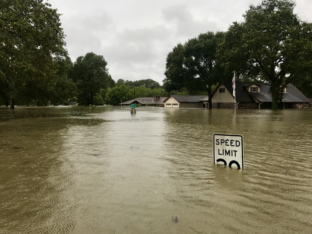
One of the most significant climate-driven shifts affecting Concan, TX is the rise in rainfall variability. Historically, the Hill Country region has experienced seasonal rains with relatively predictable patterns. Today, however, intense downpours are becoming more frequent and more severe, often interspersed with periods of prolonged drought. This volatility is reshaping the hydrology of local rivers and creeks, including the Frio River, where sudden and powerful surges can overwhelm previously sufficient flood mitigation systems. In this environment, flood elevations — the vertical measurement from a reference point to the potential floodwater surface — can change dramatically from year to year. For property owners in Concan, understanding these fluctuating flood elevations is no longer a theoretical exercise but a practical necessity.
As heavy storms become more common, the need for a reliable Flood Elevation Certificate has grown. This document, usually prepared by licensed land surveying professionals in Texas, verifies the elevation of a structure relative to the Base Flood Elevation (BFE). With increasing rainfall and flash flood events, FEMA flood maps are frequently updated, requiring residents and builders to re-examine their flood risk in a rapidly changing environment. Land Surveying in Concan, TX has thus become a vital tool in providing the data necessary to support insurance decisions, permitting processes, and safety planning.
Rising Temperatures and Their Effect on Flood Dynamics
While rainfall is a key driver of flooding, rising temperatures in Texas also play a subtle but important role. Warmer weather increases evaporation rates, which can intensify periods of drought and leave soils parched and less capable of absorbing heavy rain when storms do arrive. As a result, runoff volumes can be far greater than in the past, with water flowing over hardened, sun-baked ground straight into rivers, streams, and low-lying neighborhoods. In Concan, TX, where vacation homes, cabins, and businesses cluster near the Frio River, this phenomenon means floods can develop faster and reach higher elevations than previously anticipated.
Flood modeling systems are still catching up with the cumulative impact of these temperature-related changes. Traditional models that assumed relatively consistent infiltration and groundwater recharge rates may now be underestimating how quickly floodwaters can rise. As a result, property owners who once considered their land safe based on older surveys may find that their Flood Elevation Certificate no longer accurately reflects the current risk. In these situations, hiring professional land surveying services in Texas becomes essential to revalidate property elevations and to plan flood-resistant designs for new construction or renovations.
Land Use Changes and Compounded Flood Risks
Beyond weather alone, human-driven changes to the landscape in Concan, TX have further complicated flood elevation dynamics. Over the last several decades, more homes, roads, and parking lots have been constructed throughout the region to support tourism and recreation around the Frio River. These developments often add significant amounts of impermeable surfaces, which accelerate the speed and quantity of stormwater runoff. When these land use changes are combined with increasingly erratic weather patterns, the result is a perfect storm for more severe and unpredictable flooding.
Flood elevation and risk assessments must now account for both climate factors and the built environment. Updated land surveys that incorporate new impervious surfaces are essential for providing an accurate picture of potential water flow paths and flood extents. In Texas, these surveys are frequently used to update Flood Elevation Certificates, which then inform local planning boards, insurance underwriters, and emergency management agencies. In Concan, with its rapid seasonal population growth and heavy tourist influx during summer, these certificates play a crucial role in maintaining safety and resilience. They serve not only to protect property owners but also to support broader community disaster preparedness efforts.
The Role of Flood Elevation Certificates in a Changing Climate
Against this backdrop of shifting weather patterns, higher temperatures, and expanding development, the importance of maintaining a current and accurate Flood Elevation Certificate cannot be overstated. In Concan, TX, these certificates have evolved from a box-checking exercise into an essential planning tool that guides insurance premiums, construction codes, and emergency evacuation strategies. They provide a standardized reference for how high floodwaters might rise in a given location, allowing property owners to make informed decisions about protecting their homes and businesses.
Because flood risk is now so dynamic, property owners are encouraged to review and, if necessary, update their certificates regularly. Modern land surveying techniques in Texas — using GPS, lidar, and advanced GIS modeling — have made it easier than ever to generate highly accurate flood elevation data. These tools can account for changes in river channels, sediment build-up, and shifting topographies caused by heavy rains and floods. By investing in a new or updated Flood Elevation Certificate, Concan residents can gain peace of mind, knowing they are prepared for the increasing risks of extreme weather.
Furthermore, local governments and agencies use aggregated data from these certificates to guide regional flood management policies. As the climate continues to evolve, floodplain maps and hazard mitigation plans will depend on up-to-date elevation surveys to allocate resources, design new infrastructure, and develop flood warning systems. In Concan, this proactive approach is essential to preserving its status as a vibrant, safe community.
Future Strategies for Adapting to Flood Risk in Concan
Looking ahead, Concan, TX faces a complex challenge: how to adapt to more intense and unpredictable flooding without sacrificing the natural beauty and economic vitality that make the area so appealing. Land Surveying professionals will continue to play a central role in this effort, providing the technical expertise required to measure, model, and map flood elevations with ever greater precision. As part of a broader resilience strategy, community leaders may also need to encourage the use of more flood-resistant building materials, elevate critical infrastructure, and expand green infrastructure projects that help absorb rainwater naturally.
Public education will be critical to these efforts. Many homeowners and business owners in Concan may still not fully understand the value of their Flood Elevation Certificate or the meaning of floodplain designations. Outreach campaigns, workshops, and incentives for updating certificates can help close this knowledge gap. Equally important will be partnerships between local officials, surveyors, insurance companies, and residents to ensure that flood mitigation efforts are coordinated and comprehensive.
Finally, as Texas continues to experience dramatic weather swings — from record droughts to torrential rain — a mindset of flexibility and preparedness will serve Concan best. Communities that recognize the reality of climate change and proactively update their flood risk assessments will be best positioned to protect people, property, and their treasured Hill Country lifestyle. By respecting the power of water and acknowledging that flood elevations are no longer static but dynamic, Concan can build a more resilient and secure future.
Conclusion
Changing weather patterns are forcing a reevaluation of flood risk and flood elevation in Concan, TX. With heavier rains, higher temperatures, and ongoing land use changes, the stakes are higher than ever. Through vigilant land surveying, updated Flood Elevation Certificates, and community-wide education, Concan can rise to meet these challenges and safeguard its people and its future.
Need Land Surveyors in Texas?
At Smyth Surveyors, Inc., we offer professional, official, and dependable land surveying in Texas. Our staff are all trained and licensed with our owner holding an L.S.L.S license. We can offer surveying for gas and oil well locations, pipeline right-of-way acquisition and construction alignment, determination of original survey boundaries, title boundary surveys, topographic surveys, and construction staking. If you are looking for a surveying company that has a prestigious record and an impeccable reputation look no further than Smyth Surveyors, Inc. Contact us today to speak with one of our friendly project managers and set up some time with us!